
Knock of Alves facts for kids
.jpg)
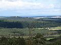
Looking across to Knock of Alves from the south with York Tower on the summit.
|
|

Knock of Alves
Location in Moray
|
|
| Coordinates | 57°38′53″N 3°24′14″W / 57.648°N 3.4040°W |
|---|---|
| Type | Hill fort, Stone circle |
| Height | 335 feet (102 m) AOD |
| History | |
| Material | Stone, earth |
The Knock of Alves is a small, tree-covered hill in Scotland. It's about 3 miles (5 km) west of Elgin in Moray. The hill stands 335 feet (102 meters) tall.
At the very top of the hill, you'll find two interesting structures. One is York Tower, a tall, octagonal building with three floors. It was built in 1827 to remember Prince Frederick, the Duke of York. The other is the Forteath Mausoleum, built in 1850. This building is a burial place for seven members of the Forteath family.
Knock of Alves is also an important historical site. It was once home to a hill fort. People lived here during the Iron Age and later the Picts. Some people believe an early Christian church might have been on the hill. However, no signs of it have been found yet.
On the south side of the hill, about 200 meters (656 feet) from the top, there's a stone circle. It has six large boulders, some as tall as 1.3 meters (4.3 feet). These stones are arranged in a circle about 10 meters (33 feet) wide.
Contents
Ancient Hill Fort at Knock of Alves
The Knock of Alves is famous for its ancient hill fort. This type of fort was a strong, protected settlement. It is similar to other forts in Scotland like Craig Phadrig and Tap o' Noth. These forts were often built very strongly. Sometimes, their stone walls were even heated so much they turned glassy, a process called vitrification.
Today, the remains of the fort are a bit damaged. This is due to the building of York Tower and the mausoleum. Also, access roads, tree roots, and animal burrows have caused some wear.
Exploring the Fort's Layout
Experts from the Royal Commission on the Ancient and Historical Monuments of Scotland studied the fort in 1957. They found several layers of walls.
The innermost area was about 125 feet (38 meters) from east to west. It was 75 feet (23 meters) from north to south. You can still see parts of its ruined wall. This inner area was inside a second, larger enclosure. This second area measured about 415 feet (126 meters) by 75 feet (23 meters). It had a clear line of large stones.
The main entrance to both these areas was on the east side. It's possible the smaller inner area was built later. It might have been constructed on top of the ruins of the larger one. A third wall surrounded both of these inner enclosures. This outer wall was mostly just scattered stones.
Outer Defenses of the Hill Fort
Two more ramparts, or defensive banks, ran around the lower parts of the hill. These were made of rubble and earth. The inner rampart enclosed an area of about 500 feet (152 meters) from east to west. It was 180 feet (55 meters) from north to south. The outer rampart was about 18 feet (5.5 meters) further out.
When Was the Fort Used?
In 2016, archaeologists dug up parts of the fort. They found evidence that people lived here a very long time ago. In the upper part of the fort, they found traces from 400-200 BC. This was during the Iron Age.
They also found signs that the fort was used again much later. The lower ramparts had materials dating from 330-540 AD. This means the site was reoccupied and made stronger during the early medieval period.
Images for kids
-
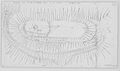
1957 survey of the hill fort
-
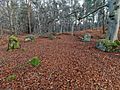
Stone circle, 200m south of the summit
-
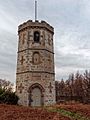
York Tower, built on the summit in 1827
-
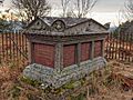
The Forteath Mausoleum, built in 1850
-
View from Buinach Hill to the south, with the Moray Firth and the hills of Sutherland beyond

.jpg)
.jpg)
.jpg)
.jpg)
