Koolewong, New South Wales facts for kids
Quick facts for kids KoolewongCentral Coast, New South Wales |
|||||||||||||||
|---|---|---|---|---|---|---|---|---|---|---|---|---|---|---|---|

Koolewong, Central Coast, NSW
|
|||||||||||||||
| Population | 920 (2021 census) | ||||||||||||||
| • Density | 460/km2 (1,200/sq mi) | ||||||||||||||
| Postcode(s) | 2256 | ||||||||||||||
| Elevation | 9 m (30 ft) | ||||||||||||||
| Area | 2 km2 (0.8 sq mi) | ||||||||||||||
| Location | |||||||||||||||
| LGA(s) | Central Coast Council | ||||||||||||||
| Parish | Patonga | ||||||||||||||
| State electorate(s) | Gosford | ||||||||||||||
| Federal Division(s) | Robertson | ||||||||||||||
|
|||||||||||||||
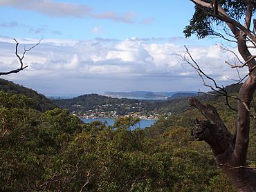
Koolewong is a small town, also called a suburb, located on the Central Coast of New South Wales, Australia. It sits between the larger towns of Gosford and Woy Woy. Most of Koolewong is built on a hill, giving it great views over Brisbane Water. It is part of the Central Coast Council, which is the local government body that manages the area.
Koolewong has its own train station. This station is on the important Main North railway line, making it easy for people to travel.
The land around Koolewong changes quite a bit. To the southeast, it is mostly flat. However, if you go northwest, you will find many hills. The highest point nearby is about 150 metres tall. It is located just 1 kilometre south of Koolewong. The closest bigger town is Umina, which is about 6.5 kilometres south. The area around Koolewong is known for having many beautiful coves, bays, and beaches.
Contents
Koolewong's History
What's in a Name?
The name "Koolewong" comes from a local Aboriginal word. It is the Aboriginal word for a Koala. This shows a connection to the native wildlife of Australia.
How Koolewong Got Its Name
Koolewong was not always called Koolewong. It was first known as "Glenrock." However, when the NSW Railways decided to build a train station there, they chose the name Koolewong for the station. Because of this, the whole area soon became known as Koolewong too.
Population Growth
The number of people living in Koolewong has been growing. In the year 2021, a census (a count of the population) showed that 920 people lived there. This was an increase from the 871 people recorded in the 2016 census.
Koolewong Marina Opens
A new and important addition to Koolewong was the Koolewong Marina. This marina, a place where boats can dock, was officially opened in February 2017.
 | Leon Lynch |
 | Milton P. Webster |
 | Ferdinand Smith |

