
Kopu Bridge facts for kids
Quick facts for kids Historic Kopu Bridge |
|
|---|---|

Looking east over the old bridge
|
|
| Carries | Vehicles |
| Crosses | Waihou River |
| Locale | Hauraki Plains / Coromandel Peninsula |
| Maintained by | NZ Transport Agency |
| Characteristics | |
| Design | Swing bridge |
| Material | Timber piling, concrete piers, steel plate girder spans |
| Total length | 463 m |
| Width | 4 m, with passing bays (use ceased after signalisation) |
| Longest span | 42.7 m (swing span), creating a 15.3 m wide shipping channel |
| Number of spans | 23 |
| History | |
| Designer | J. E. L. Cull |
| Construction begin | 1926 |
| Construction end | 1928 |
| Statistics | |
| Daily traffic | 9000 |
| Designated | 13 December 1990 |
| Reference no. | 4681 |
| (New) Kopu Bridge | |
|---|---|

New bridge being built in early 2010. Working deck shown only, final bridge level much higher
|
|
| Carries | Vehicles, bicycles & pedestrians |
| Crosses | Waihou River |
| Locale | Hauraki Plains / Coromandel Peninsula |
| Maintained by | NZ Transport Agency |
| Characteristics | |
| Material | Concrete, steel girders |
| Total length | 587 m |
| Longest span | 42.8 m |
| Number of spans | 16 |
| Clearance below | 6.5 m above mean sea level |
| History | |
| Construction begin | 2009 |
| Construction end | 2011 |
| Opened | 2011 |
The Historic Kopu Bridge is a famous single-lane swing bridge in New Zealand. It crosses the Waihou River near the Firth of Thames in the Thames-Coromandel District. This bridge was finished in 1928 and was an important part of State Highway 25.
At 463 metres long, it was the longest and oldest single-lane bridge on the state highway network. It's also special because it's New Zealand's only remaining working swing bridge. A swing bridge has a part that can open up to let boats pass through. The middle part of the Kopu Bridge that swings is 43 metres long.
The Kopu Bridge was the main way to cross the Waihou River. It connected the Hauraki Plains and the Coromandel Peninsula. This meant it got very busy, especially during holidays. By the early 1990s, about 9,000 vehicles used it every day. Because it was only one lane, traffic lights controlled the flow. People often had to wait for hours during busy times.
Even though boat traffic on the river became less common, the swing part of the bridge could still open. It created a 15.3-metre wide channel for passing ships. The bridge is now a protected historic place. Heritage New Zealand lists it as a Category 1 historic site.
In December 2011, a new two-lane bridge opened right next to the old one. The old bridge was almost taken down. However, a local group called the Historic Kopu Bridge Society worked to save it. They wanted it to become a path for walking and cycling. This way, it could stay as New Zealand's last working swing bridge. The old bridge was given to a community group in 2018.
Contents
Building the Bridges
The Old Bridge's Story
The original Kopu Bridge was built in 1928. Plans for it started way back in 1911. It was a huge project for its time. The bridge had 23 sections and used special deep foundations. These were needed because the riverbed ground was very soft.
Before the bridge, people used barges and ferries to cross the Waihou River. The bridge connected Thames to new dairy farms in the Hauraki Plains. It made a big difference to the area. It showed that roads were becoming more important than river transport. Thames also changed from a mining town to a farming town.
Until the 1960s, drivers used special passing areas on the bridge. But people started getting angry about who should go first. So, traffic lights were put in. After the lights, more cars meant longer queues. This led to calls for a new bridge.
Why a New Bridge Was Needed
The old bridge was getting too busy. Traffic was expected to keep growing. Also, studies in 2001 showed the old bridge might be badly damaged in a strong earthquake. It didn't meet modern safety rules for earthquakes. So, in 2006, it was decided to build a new bridge. Construction started in late 2009.
The New Bridge
The new Kopu Bridge is 587 metres long. It has 16 sections. Its foundations go very deep into the riverbed, between 36 and 50 metres. This was necessary because the ground was soft and swampy.
The new bridge was designed with special features. It includes images of traditional Māori canoes and taniwha (water spirits). Native plants were used for the landscaping around it. The new bridge cost about $47–48 million. This included 2.5 km of new road and a new roundabout.
The new bridge has a wide channel for boats. It is 42.8 metres wide and 6.5 metres above sea level. This means larger boats can pass underneath without the bridge needing to swing open. The new bridge was finished in late 2011, just in time for the busy December holidays.
What Happened to the Old Bridge?
Because the old bridge is so important to history, people wanted to save it. There were ideas to turn it into a path for bikes and walkers. The new bridge already has paths for cyclists and pedestrians. However, the old bridge was officially given to a community group on March 19, 2018. This means it can be preserved for future generations.
Images for kids
-
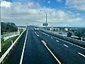
Kopu Bridge in 2021 looking west. The old bridge is to the right

See also
 In Spanish: Puente Kopu para niños
