Korochansky District facts for kids
Quick facts for kids Korochansky DistrictКороча́нский райо́н (Russian) |
|
|---|---|
 |
|
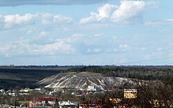
 Mount Belaya, a protected area of Russia in Korochansky District |
|
|
|
|
| Location | |
| Country | Russia |
| Federal subject | Belgorod Oblast |
| Administrative structure (as of May 2015) | |
| Administrative center | town of Korocha |
| Inhabited localities: | |
| Cities/towns | 1 |
| Rural localities | 127 |
| Municipal structure (as of December 2013) | |
| Municipally incorporated as | Korochansky Municipal District |
| Municipal divisions: | |
| Urban settlements | 1 |
| Rural settlements | 22 |
| Statistics | |
| Area | 1,464.1 km2 (565.3 sq mi) |
| Population (2010 Census) | 38,695 inhabitants |
| • Urban | 15.2% |
| • Rural | 84.8% |
| Population (January 2015 est.) | 38,967 inhabitants |
| Density | 26.43/km2 (68.5/sq mi)* |
| Time zone | MSK (UTC+04:00) |
| Established | July 30, 1928 |
| Official website: http://www.korocha.ru | |
| [[:commons:Category:{{#property:Commons category}}|Korochansky District]] on WikiCommons | |
| 2021 Census | 35,883 |
|---|---|
| 2010 Census | 38,695 |
| 2002 Census | 39,722 |
| 1989 Census | 39,409 |
| 1979 Census | 44,654 |
Korochansky District (Russian: Короча́нский райо́н) is a special area, or raion, in Belgorod Oblast, Russia. Think of it like a county or a region within a larger state. It's located right in the middle of Belgorod Oblast. The district covers an area of about 1,464 square kilometers, which is roughly 565 square miles.
The main town and administrative center of Korochansky District is Korocha. In 2021, the district had a total population of about 35,883 people. The town of Korocha itself is home to about 15.7% of all the people living in the district.
Contents
History of Korochansky District
The story of Korochansky District began a long time ago, in the early 1600s. This was when Russia started building a special defense line called the Belgorod frontier. This frontier was built to protect against raids from groups like the Crimean Tatars and Nogais.
Building Fortresses
In 1637, construction began on a fortress city called Yablonov. It was built to block an important route used by raiders. Just one year later, in the spring of 1638, another fortress town named Korocha was built. Korocha quickly became an important center for the surrounding area.
Changes Over Time
For many years, the Korocha area was known as Korocha uyezd. This was an administrative area that included Korocha town and nearby settlements. It was part of the larger Belgorod region.
- 1708: Peter the Great made changes to how Russia was organized. Korocha uyezd was officially ended and became part of the Kiev province.
- 1727: The Belgorod province was created, and Korocha uyezd was brought back as part of it.
- 1779: Empress Catherine the Great made more changes. The Belgorod province was abolished. Korocha uyezd changed its borders and became part of the Kursk governorship.
- 1796: The Kursk governorship became the Kursk Province. The borders of Korocha uyezd changed again, with some parts moving to other areas and new parts joining.
- 1802: The borders were adjusted one more time. From 1802 until 1924, Korocha uyezd stayed mostly the same.
Forming the Modern District
In 1924, Korocha uyezd was abolished and its land became part of a larger Belgorod uyezd. However, the modern Korochansky District was officially formed on July 30, 1928. It was part of the Belgorod district within the Central-Chernozem region.
Since then, the district has been part of different larger regions:
- June 13, 1934: It became part of Kursk Oblast.
- January 6, 1954: It joined Belgorod Oblast, where it remains today.
In 2006, Korochansky District was given the status of a "municipal district." This means it has its own local government. Today, the district has 23 local government areas: one urban area (Korocha town) and 22 rural areas.


