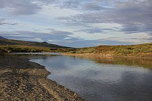
Kougarok River facts for kids
Quick facts for kids Kougarok River |
|
|---|---|

Kougarok River
|
|
|
Location of the mouth of the Kougarok River in Alaska
|
|
| Native name | Kuuguraq |
| Country | United States |
| State | Alaska |
| District | Nome Census Area |
| Physical characteristics | |
| Main source | Confluence of Macklin and Washington creeks Seward Peninsula 457 ft (139 m) 65°41′00″N 164°47′46″W / 65.68333°N 164.79611°W |
| River mouth | Kuzitrin River 47 miles (76 km) southwest of Imuruk Lake 75 ft (23 m) 65°15′23″N 164°33′57″W / 65.25639°N 164.56583°W |
| Length | 45 mi (72 km) |
The Kougarok River (say it: Koo-gah-rok) is a river in Alaska, a state in the United States. Its name in the Inupiaq language is Kuuguraq, which means "little river." This river starts when two smaller streams, Macklin Creek and Washington Creek, join together.
The Kougarok River is about 45 miles (72 km) long. It flows mostly south from an area near Taylor Airport. The river is an important part of the Seward Peninsula in Alaska.
Where the Kougarok River Flows
The Kougarok River eventually flows into the Kuzitrin River. From there, the water travels west into a larger area called the Imuruk Basin. This basin is connected to a bay called Port Clarence. Port Clarence is part of the huge Bering Sea. So, the Kougarok River's water makes a long journey to the sea!
History of the Kougarok River
In the year 1900, this river was known by a slightly different name, the Kugruk River. Later on, its name was officially changed to Kougarok River.
In the early 1900s, many people came to the Kougarok River area. They were looking for gold! Gold mining was a big activity here for a while. However, after World War II ended, the amount of mining and development in the area slowed down.
Traveling Along the River
If you wanted to travel along the Kougarok River, you would find a road nearby. The Nome-Taylor Highway follows the river for much of its path. This means you can drive alongside the river and see its beauty for many miles.


