
Kresta Bay facts for kids
Quick facts for kids Kresta Bay |
|
|---|---|

Kresta Bay
Location in Chukotka Autonomous Okrug
|
|
 |
|
| Location | Far North |
| Coordinates | 66°00′00″N 179°15′00″W / 66.000°N 179.250°W |
| Native name | Залив Креста Error {{native name checker}}: parameter value is malformed (help) |
| River sources | Tnekveem |
| Ocean/sea sources | Gulf of Anadyr |
| Basin countries | Russia |
| Max. length | 102 km (63 mi) |
| Max. width | 43 km (27 mi) |
| Average depth | 70 m (230 ft) |
| Settlements | Egvekinot |
Kresta Bay (also called Kresta Gulf) is a big bay in Russia. It's located on the southern coast of the Chukotka Peninsula. This bay is part of the larger Gulf of Anadyr. Kresta Bay is managed by the Iultinsky District in the Chukotka region.
About Kresta Bay
Kresta Bay is open towards the south. It stretches for almost 100 kilometers (about 62 miles) in length. The bay has an average width of about 43 kilometers (about 27 miles). Inside the bay, you can find two smaller inlets. There is also a coastal lagoon, which is a shallow body of water separated from the main bay by a strip of land.
Today, Kresta Bay is a place where tourists like to visit. Near the bay is Kresta Bay Airport. This airport is served by Chukotavia, an airline that helps people travel to and from the area. The airport is close to Egvekinot, which is a small harbor town located on the bay.
History of the Bay
The Kresta Bay was first explored and mapped by a Russian sailor. His name was Count Fyodor Petrovich Litke. He surveyed the bay in the year 1828.
Images for kids
-
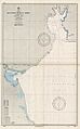
An old U.S. Navy map showing Kresta Bay on its upper right corner.
-
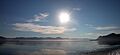
A view of Kresta Bay.


