
La Chapelle-Monthodon facts for kids
Quick facts for kids
La Chapelle-Monthodon
|
|
|---|---|
|
Part of Vallées-en-Champagne
|
|
 |
|

La Chapelle-Monthodon
Location in France

La Chapelle-Monthodon
Location in Hauts-de-France
|
|
| Country | France |
| Region | Hauts-de-France |
| Department | Aisne |
| Arrondissement | Château-Thierry |
| Canton | Condé-en-Brie |
| Commune | Vallées-en-Champagne |
| Area
1
|
14.28 km2 (5.51 sq mi) |
| Population
(2021)
|
199 |
| • Density | 13.94/km2 (36.09/sq mi) |
| Time zone | UTC+01:00 (CET) |
| • Summer (DST) | UTC+02:00 (CEST) |
| Postal code |
02330
|
| Elevation | 112–254 m (367–833 ft) (avg. 113 m or 371 ft) |
| 1 French Land Register data, which excludes lakes, ponds, glaciers > 1 km2 (0.386 sq mi or 247 acres) and river estuaries. | |
La Chapelle-Monthodon was once a small village, known in France as a "commune." It was located in the northern part of France, in a region called Hauts-de-France. Specifically, it was part of the Aisne department.
On January 1, 2016, La Chapelle-Monthodon joined with other nearby villages. It became part of a new, larger commune named Vallées-en-Champagne. This means it is no longer a separate commune on its own.
How Many People Lived There?
The number of people living in La Chapelle-Monthodon changed over the years. In 1962, there were 193 residents. The population went down for a while, reaching 148 people in 1975.
Later, the number of residents started to grow again. By 1999, 209 people called the village home. Just before it merged, in 2008, about 183 people lived in La Chapelle-Monthodon.
| Historical population | ||
|---|---|---|
| Year | Pop. | ±% |
| 1962 | 193 | — |
| 1968 | 178 | −7.8% |
| 1975 | 148 | −16.9% |
| 1982 | 166 | +12.2% |
| 1990 | 173 | +4.2% |
| 1999 | 209 | +20.8% |
| 2008 | 183 | −12.4% |
Images for kids
-
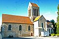
The church in La Chapelle-Monthodon.
See also
 In Spanish: La Chapelle-Monthodon para niños
