La Prairie, Illinois facts for kids
Quick facts for kids
La Prairie
|
|
|---|---|

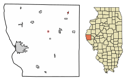
Location of La Prairie in Adams County, Illinois.
|
|

Location of Illinois in the United States
|
|
| Country | United States |
| State | Illinois |
| County | Adams |
| Township | Northeast |
| Incorporated | April 15, 1869 |
| Area | |
| • Total | 0.19 sq mi (0.50 km2) |
| • Land | 0.19 sq mi (0.50 km2) |
| • Water | 0.00 sq mi (0.00 km2) 0% |
| Elevation | 709 ft (216 m) |
| Population
(2020)
|
|
| • Total | 42 |
| • Density | 217.62/sq mi (84.11/km2) |
| Time zone | UTC-6 (CST) |
| • Summer (DST) | UTC-5 (CDT) |
| ZIP Code(s) |
62346
|
| Area code(s) | 217 |
| FIPS code | 17-42080 |
| GNIS feature ID | 2398368 |
| Wikimedia Commons | La Prairie, Illinois |
La Prairie is a small village located in Adams County, Illinois, in the United States. It's a quiet community with a very small population. In 2020, only 42 people lived there. The village is part of the Quincy, IL–MO Micropolitan Statistical Area, which is a group of nearby towns and cities. La Prairie was officially established on April 15, 1869.
Where is La Prairie?
La Prairie is found in the western part of Illinois. It is located at coordinates 40.148301 degrees North and -91.002433 degrees West. The village covers a total area of about 0.19 square miles (0.50 square kilometers). All of this area is land, meaning there are no lakes or large rivers within the village limits.
Who Lives in La Prairie?
Let's look at how the number of people living in La Prairie has changed over the years.
| Historical population | |||
|---|---|---|---|
| Census | Pop. | %± | |
| 1880 | 233 | — | |
| 1890 | 194 | −16.7% | |
| 1900 | 182 | −6.2% | |
| 1910 | 187 | 2.7% | |
| 1920 | 174 | −7.0% | |
| 1930 | 146 | −16.1% | |
| 1940 | 141 | −3.4% | |
| 1950 | 142 | 0.7% | |
| 1960 | 115 | −19.0% | |
| 1970 | 85 | −26.1% | |
| 1980 | 90 | 5.9% | |
| 1990 | 68 | −24.4% | |
| 2000 | 60 | −11.8% | |
| 2010 | 47 | −21.7% | |
| 2020 | 42 | −10.6% | |
| U.S. Decennial Census | |||
The population of La Prairie has slowly become smaller over time. In 1880, there were 233 people, but by 2020, this number had dropped to 42.
La Prairie's Population Details
According to the 2020 census, there were 42 people living in La Prairie. These people lived in 28 different homes, and 21 of these were families. The village has a population density of about 217 people per square mile. This means that for every square mile of land, there are about 217 people.
About 39.3% of the homes had children under 18 years old living there. Most homes, about 71.43%, were married couples living together. The average number of people in each home was 2.71.
The age of the people in La Prairie varies. About 21.9% of the population was under 18 years old. The median age, which is the middle age of all the people, was 40.6 years. This means half the people were younger than 40.6 and half were older.
See also
 In Spanish: La Prairie (Illinois) para niños

