La Rochette, Hautes-Alpes facts for kids
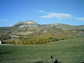
La Rochette is a small town in the Hautes-Alpes department in France. It's a quiet place with a rich history, located in a beautiful mountainous area. The town is known for its stunning views, including "Napoleon's Hat" and Puy de Manse, which are nearby mountains.
Quick facts for kids
La Rochette
|
||
|---|---|---|

A view of La Rochette with Napoleon's Hat at 1,425 m (4,675 ft) and Puy de Manse at 1,646 m (5,400 ft)
|
||
|
||
| Country | France | |
| Region | Provence-Alpes-Côte d'Azur | |
| Department | Hautes-Alpes | |
| Arrondissement | Gap | |
| Canton | Chorges | |
| Area
1
|
10.34 km2 (3.99 sq mi) | |
| Population
(Jan. 2019)
|
474 | |
| • Density | 45.84/km2 (118.73/sq mi) | |
| Time zone | UTC+01:00 (CET) | |
| • Summer (DST) | UTC+02:00 (CEST) | |
| INSEE/Postal code |
05124 /05000
|
|
| Elevation | 779–1,631 m (2,556–5,351 ft) (avg. 1,100 m or 3,600 ft) |
|
| 1 French Land Register data, which excludes lakes, ponds, glaciers > 1 km2 (0.386 sq mi or 247 acres) and river estuaries. | ||
How Many People Live Here?
The number of people living in La Rochette has changed over the years. In 2019, about 474 people called La Rochette home. This number helps us understand the size of the community.
| Historical population | ||
|---|---|---|
| Year | Pop. | ±% |
| 1962 | 276 | — |
| 1968 | 282 | +2.2% |
| 1975 | 314 | +11.3% |
| 1982 | 368 | +17.2% |
| 1990 | 397 | +7.9% |
| 1999 | 375 | −5.5% |
| 2008 | 380 | +1.3% |
Getting Around
Roads
Several roads help people travel to and from La Rochette. These include the D14, D292, D314, and N94 roads. They connect the town to other places in the region.
See also
 In Spanish: La Rochette (Altos Alpes) para niños
Black History Month on Kiddle
African-American Women you should know
 | Anna J. Cooper |
 | Mary McLeod Bethune |
 | Lillie Mae Bradford |

All content from Kiddle encyclopedia articles (including the article images and facts) can be freely used under Attribution-ShareAlike license, unless stated otherwise. Cite this article:
La Rochette, Hautes-Alpes Facts for Kids. Kiddle Encyclopedia.


