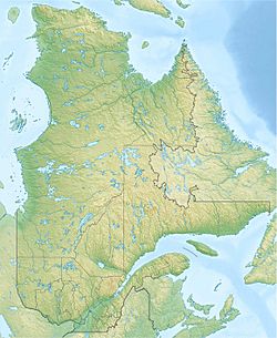
Lac au Bouleau (Mont-Élie) facts for kids
Quick facts for kids Lac au Bouleau |
|
|---|---|
| Location | Mont-Élie |
| Coordinates | 47°58′14″N 70°15′13″W / 47.97055°N 70.25361°W |
| Lake type | Natural |
| Primary inflows | Petit Saguenay River and outlet of Lac Armand |
| Primary outflows | Petit Saguenay River |
| Basin countries | Canada |
| Max. length | 4.3 km (2.7 mi) |
| Max. width | 0.9 km (0.56 mi) |
| Surface elevation | 449 m (1,473 ft) |
Lac au Bouleau is a lake in Quebec, Canada. It's special because the Petit Saguenay River flows right through it. The river enters from the south and leaves from the north. This lake is located in an area called Mont-Élie, which is part of the Charlevoix-Est Regional County Municipality.
A forest road, R064, helps people get close to the lake. It comes within about 0.6 km (0.37 mi) of Lac au Bouleau. The main activities in this area are forestry, which means managing forests and cutting trees, and also tourism, like fishing or hiking.
The lake usually freezes over from late November until early April. It's generally safe to walk or play on the ice from mid-December to the end of March.
Contents
Discovering Lac au Bouleau
Lac au Bouleau is about 4.3 km (2.7 mi) long. It has a unique shape that looks a bit like a winter boot! The river flows into the "toe" part and leaves from the "top" part of the boot.
Nearby Waters
Many other lakes and rivers are close to Lac au Bouleau. These are called "watersheds" because they all connect and share water.
- To the north, you'll find Emmuraillé Lake and Pilote Lake. The Petit Saguenay River also continues north.
- To the east, there's McLagan Lake, Étienne Brook, Deschênes Lake, and the Deschênes River.
- To the south, you'll see Lac au Sable and ruisseau au Sable. The Petit Saguenay River also flows from the south.
- To the west, there's Lac Bazile and coulée du Bazile.
The Journey of the Petit Saguenay River
The Petit Saguenay River is quite busy! Before reaching Lac au Bouleau, it flows through Lac au Sable. After leaving Lac au Bouleau, it continues into the eastern part of Lac Emmuraillé.
- Lac au Sable is about 2.7 km (1.7 mi) long and sits at an altitude of 449 m (1,473 ft).
- Lac au Bouleau is 4.3 km (2.7 mi) long and also at 449 m (1,473 ft) altitude.
- Lac Emmuraillé is about 1.8 km (1.1 mi) long and is a bit lower at 436 m (1,430 ft) altitude.
Where the Water Goes
The water leaving Lac au Bouleau travels a long way!
- It's about 10.4 km (6.5 mi) west of lac Deschênes.
- It's also about 28.4 km (17.6 mi) south of the small village of Petit-Saguenay.
- The lake is 29.5 km (18.3 mi) south of where the Petit Saguenay River meets the big Saguenay River.
From Lac au Bouleau, the water flows along the Petit Saguenay River for about 66.8 km (41.5 mi). Then, it joins the Saguenay River, which flows east for 36.6 km (22.7 mi) all the way to Tadoussac. Finally, the water from Lac au Bouleau reaches the huge St. Lawrence River!
Why the Name Lac au Bouleau?
The name "Lac au Bouleau" means "Birch Lake" in French. Birch trees are very common in places with cold or mild weather. They have white bark and small leaves. People use birch wood for many things, like making furniture or paper.
The name "Lac au Bouleau" was officially recognized on December 5, 1968, by the Commission de toponymie du Québec, which is a group that names places in Quebec.
 | Madam C. J. Walker |
 | Janet Emerson Bashen |
 | Annie Turnbo Malone |
 | Maggie L. Walker |


