
Laghouat Province facts for kids
Quick facts for kids
Laghouat Province
ولاية الأغواط
|
|
|---|---|

Map of Algeria highlighting Laghouat
|
|
| Country | |
| Capital | Laghouat |
| Area | |
| • Total | 25,057 km2 (9,675 sq mi) |
| Population
(2008)
|
|
| • Total | 477,328 |
| • Density | 19.0497/km2 (49.3385/sq mi) |
| Time zone | UTC+01 (CET) |
| Area Code | +213 (0) 29 |
| ISO 3166 code | DZ-03 |
| Districts | 10 |
| Municipalities | 24 |
Laghouat is a province (also called a wilaya) in central Algeria. The name "Laghouat" means "the oases," which are green, fertile spots in a desert. The main city and capital of this province is Laghouat. Other important towns and areas in the province include Aflou, Ain Madhi, Kourdane, and Makhareg.
Contents
Understanding Laghouat Province
Laghouat Province is a region in the middle of Algeria. It's known for its beautiful oases. These are places where water comes to the surface, allowing plants to grow and people to live, even in dry areas.
How Laghouat Province is Organized
The province is divided into smaller parts to help manage it better. These parts are called districts. Laghouat Province has 10 districts. Inside these districts, there are even smaller areas called communes or municipalities. There are 24 of these in total.
Districts of Laghouat
Here are the 10 districts that make up Laghouat Province:
- Aflou
- Aïn Mahdi
- Brida
- El Ghicha
- Gueltet Sidi Saâd
- Hassi R'Mel
- Ksar El Hirane
- Laghouat (This is where the capital city is located)
- Oued Morra
- Sidi Makhlouf
Images for kids
-
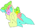
Districts of Laghouat Province
-
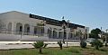
Laghouat Airport
-
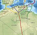
The strategic energy importance of the Hassi Ramel gas field


See also
 In Spanish: Provincia de Laghouat para niños
