
Laguna District facts for kids
Quick facts for kids
Laguna
|
|
|---|---|
|
District
|
|

Our Lady of the Rosary Church
|
|

Laguna
Location in Costa Rica
|
|
| Country | |
| Province | Alajuela |
| Canton | Zarcero |
| Area | |
| • Total | 23.36 km2 (9.02 sq mi) |
| Elevation | 1,840 m (6,040 ft) |
| Population
(2011)
|
|
| • Total | 1,674 |
| • Density | 71.66/km2 (185.60/sq mi) |
| Time zone | UTC−06:00 |
| Postal code |
21102
|
Laguna is a small area, called a district, located in the Zarcero canton. This canton is part of the Alajuela province in the country of Costa Rica.
Contents
About Laguna's Land
Laguna covers an area of about 23.36 square kilometers. It is located high up, at an elevation of about 1,840 meters (6,037 feet) above sea level.
Places in Laguna
- Villages: One of the villages in Laguna is called Peña.
People Living in Laguna
According to the 2011 census, about 1,674 people lived in Laguna.
Getting Around Laguna
Road Connections
The main road that goes through Laguna is:
- National Route 141

Images for kids
-
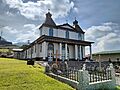
Our Lady of the Rosary Church in Laguna.
See also
 In Spanish: Laguna de Zarcero para niños

All content from Kiddle encyclopedia articles (including the article images and facts) can be freely used under Attribution-ShareAlike license, unless stated otherwise. Cite this article:
Laguna District Facts for Kids. Kiddle Encyclopedia.