Laguna de Tacarigua National Park facts for kids
Quick facts for kids Laguna de Tacarigua National ParkParque nacional Laguna de Tacarigua |
|
|---|---|
|
IUCN Category II (National Park)
|
|
 |
|
| Location | |
| Area | 391 km2 (151 sq mi) |
| Established | 1974 |
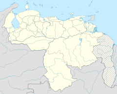
The Laguna de Tacarigua National Park, also called Tacarigua Lagoon National Park, is a special protected area in Venezuela. It's located on the eastern side of Miranda State, close to the town of Laguna de Tacarigua. This park is a huge natural space, covering about 39,100 hectares, which is like 391 square kilometers!
A big part of the park is a large coastal lagoon. This lagoon is about 7,800 hectares in size and is usually around 1.2 meters deep. A long, sandy strip of land, called a coastal barrier, separates the lagoon from the sea. This barrier is almost 29 kilometers long and between 300 to 1,000 meters wide. It was formed by ocean currents moving along the coast.
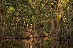
To the south of the lagoon, you'll find areas with dry forests. To the north, there's a large marine area that is part of the park. About 4,000 hectares of the park are covered by mangrove forests. These special trees grow along the lagoon's edges and even form dense islands in the middle.
The lagoon gets its fresh water mainly from the Guapo River. Other smaller streams, like Pirital and San Nicolás, also feed into it. In its northwestern part, the lagoon connects to the sea through an opening. Sometimes, if there's not enough rain, the Guapo River doesn't bring much fresh water. This can cause the opening to the sea to close up, making the lagoon's water saltier.
The park has three main types of natural environments. These include the shallow, slightly salty lagoon, the dry forest areas, and the sandy beach barrier. Each of these environments is home to different kinds of plants and animals.
Gallery
See also
 In Spanish: Parque nacional Laguna de Tacarigua para niños
- List of national parks of Venezuela
- Canaima National Park


