
Lake Traverse (Mékinac) facts for kids
Quick facts for kids Lake Traverse (Mékinac) |
|
|---|---|

Lake Traverse (Mékinac)
Location in Quebec
|
|
| Location | Quebec |
| Coordinates | 46°50′53″N 72°32′02″W / 46.84806°N 72.53389°W |
| Type | Natural |
| Primary inflows | Outlet of Lake Jesuit |
| Primary outflows | Rivière des Envies |
| Catchment area | Fleuve Saint-Laurent |
| Basin countries | |
| Max. length | 1.6 km (0.99 mi) |
| Max. width | 1.2 km (1 mi) |
| Surface elevation | 165 m (541 ft) |
| Settlements | Sainte-Thècle |
Lake Traverse (also called "Lake Travers") is a natural lake found in the northern part of Sainte-Thècle, a town in Quebec, Canada. It's part of the Batiscanie region. This lake is where the Rivière des Envies begins. This river then flows south towards Saint-Tite.
Contents
Exploring Lake Traverse's Geography
Lake Traverse is located about 2.9 kilometres (1.8 mi) by road from the bridge at Croche Lake (Sainte-Thècle). To get there from the village, you would take several roads. These include Saint-Michel-North road, Marcotte road, and Lake Jesuit road. There is also a special "road of the Lake Traverse" that leads to cottages on the lake's west side.
This lake sits in the northern part of Sainte-Thècle. It marks the northern edge of the old Lordship of Sainte-Anne-de-la-Pérade. Lake Traverse is at the base of the Laurentian Mountains, near the St. Lawrence Valley. This means that the farming area ends at the lake. The area to the northwest of Lake Traverse is mostly forest and mountains.
Lake Traverse has three main parts, separated by land that sticks out into the water. The western part is about 1.6 kilometres (0.99 mi) long. This is where the lake starts and where its water flows out. The middle part is about 0.9 kilometres (0.56 mi) long. The smallest part, to the east, is about 0.3 kilometres (0.19 mi) long. The lake's total width, covering all three parts, is about 1.2 kilometres (0.75 mi). You can see Hydro-Québec power lines crossing the lake from northeast to southwest. Many cottages have been built around the lake.
The Story Behind the Name: Toponymy
The name "Lake Traverse" comes from how people used to cross it. Before a main road was built, the lake was a key crossing point. It helped people reach the forest areas further north. In winter, from December to March, people would cross the frozen lake. They used horse-drawn cars to get their wood.
In spring, workers used boats or rafts to cross the lake. This helped them get from the sawmill area. Logs were floated on the lake to supply the sawmill at the lake's outlet. A special floating cable, called a "baune," was used to pull logs across the lake. This helped move logs that got stuck downstream. The name "Lake Traverse" was officially recognized on December 5, 1968. This was done by the Commission de toponymie du Québec, which names places in Quebec.
History of the Lake Traverse Area
In 1882, the Government of Quebec started building a road in Sainte-Thècle. This road, called the "row of Lake St. Joseph" or "row of Lake Traverse," helped new settlers move into the area. It opened up new opportunities for people to live and work there.
Historically, the land around Lake Traverse made it possible to reach the Lejeune Township. This area is in the northwestern part of Sainte-Thècle. However, traveling there was hard because of many rocky areas. These rocky spots were slowly removed using dynamite in the 1960s and 1970s.
Sawmill Saint-Amand
Near where Lake Traverse flows out, a man named Alfred Saint-Amand ran a sawmill. He operated it from 1902 to 1932. This sawmill used water power to cut wood. His son, Adélard Saint-Amand, and then his grandson, Rolland Saint-Amand, continued to run the mill. Another person, Frank Blais, also operated a sawmill at Lake Traverse.
Bridges at the Lake's Outlet
The first public bridge over the Rivière des Envies was built in the late 1800s. It was located near the sawmill of Alfred Saint-Amand. This bridge was part of the "government road." The first wooden bridge built by the local government was around 1933. It was only wide enough for one lane of traffic. This bridge was rebuilt in 1950 to be wide enough for two lanes. There was also a private bridge for the mill, first built in 1912. It was replaced in 1958 with a much stronger bridge.
Sweet Treats: Sugar Shacks
The area around Lake Traverse was home to many sugar shacks. These are places where maple syrup is made. Around 1900, Louis Bédard had a sugar shack on the other side of the lake. Arthur Perron later continued to operate this shack. Samuel Bédard also had a shack, which was later owned by Joseph Plamondon and then Réjean Bédard.
Alfred Huot collected maple sap on his land, which he sold to Odinat Huot. This land was later bought by Rolland Béland. George Bacon also had a sugar shack in this area, and his land was later acquired by Leandre Trudel. Other people who made maple syrup here included "Pit" Grenier and Louis Toupin. Lucien Toupin later took over Louis Toupin's operation.
Images for kids
-
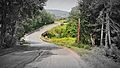
Road spanning the bridge at the mouth of Lac de la Traverse, in Sainte-Thècle. This bridge was rebuilt in 2010.

