
Lakewood (CDP), Wisconsin facts for kids
Quick facts for kids
Lakewood, Wisconsin
|
|
|---|---|
|
Census-designated place
|
|

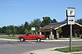
Downtown Lakewood on WIS 32
|
|

Lakewood (CDP), Wisconsin
Location in Wisconsin
|
|
| Country | United States |
| State | Wisconsin |
| County | Oconto |
| Area | |
| • Total | 2.781 sq mi (7.20 km2) |
| • Land | 2.781 sq mi (7.20 km2) |
| • Water | 0 sq mi (0 km2) |
| Elevation | 1,280 ft (390 m) |
| Population
(2010)
|
|
| • Total | 323 |
| • Density | 116.15/sq mi (44.84/km2) |
| Time zone | UTC-6 (Central (CST)) |
| • Summer (DST) | UTC-5 (CDT) |
| ZIP code |
54138
|
| Area code(s) | 715 & 534 |
| GNIS feature ID | 1579620 |
Lakewood is a small community in Oconto County, Wisconsin, United States. It's not an official city or town, but it's recognized as a census-designated place. This means it's a special area used for gathering population information.
Lakewood is found along Wisconsin Highway 32, about 22 miles (35 km) north-northwest of Suring. It has its own post office with the ZIP code 54138. In 2010, the community had a population of 323 people.
History of Lakewood
Lakewood was first planned out in 1897. It got its name because it's located near a lake surrounded by woods. The community has had a working post office since it was founded in 1897.
Images for kids
-
Nicolet State Trailhead
-
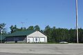
Ambulance service


See also

- In Spanish: Lakewood (condado de Oconto) para niños

All content from Kiddle encyclopedia articles (including the article images and facts) can be freely used under Attribution-ShareAlike license, unless stated otherwise. Cite this article:
Lakewood (CDP), Wisconsin Facts for Kids. Kiddle Encyclopedia.