
Suring, Wisconsin facts for kids
Quick facts for kids
Suring, Wisconsin
|
|
|---|---|
|
Village
|
|

Location of Suring in Oconto County, Wisconsin.
|
|
| Country | |
| State | |
| County | Oconto |
| Area | |
| • Total | 1.02 sq mi (2.66 km2) |
| • Land | 1.02 sq mi (2.66 km2) |
| • Water | 0.00 sq mi (0.00 km2) |
| Elevation | 801 ft (244 m) |
| Population
(2010)
|
|
| • Total | 544 |
| • Estimate
(2019)
|
522 |
| • Density | 509.27/sq mi (196.59/km2) |
| Time zone | UTC-6 (Central (CST)) |
| • Summer (DST) | UTC-5 (CDT) |
| Area code(s) | 920 |
| FIPS code | 55-78725 |
| GNIS feature ID | 1580561 |
Suring is a small village in Oconto County, Wisconsin, United States. It is located right on the 45th parallel north, which is an imaginary line halfway between the equator and the North Pole. In 2010, about 544 people lived here. Suring is also part of the larger Green Bay area.
Contents
History of Suring
This area was once the traditional home of the Menominee people. They lived here for thousands of years before Europeans arrived. Later, other Native American groups like the Oneida, Stockbridge-Munsee, and Brothertown also moved to Wisconsin.
In 1836, the Menominee signed a special agreement called the Treaty of the Cedars. Through this treaty, they shared some of their land with the United States government. This allowed new settlers to move into the area.
A post office opened in Suring in 1897. The village got its name from Julius "Joe" Suring, who owned land nearby. In the Menominee language, the village is called Naeqniw-Sīpiah, which means 'three rivers'.
Geography of Suring
Suring is located in Wisconsin, about 50.5 miles northwest of Green Bay, Wisconsin. The village covers an area of about 1.01 square miles, and all of it is land.
The Oconto River and Peshtigo Brook form the village's boundaries on the southwest side. A main road, Wisconsin Highway 32, also runs through Suring. It is joined by County Highway M.
The 45th Parallel Marker
Suring is proud of its location on the 45th parallel north. This imaginary line is exactly halfway between the equator and the North Pole. The village even has a special marker to show this unique spot.
Suring's Climate
| Climate data for Suring, Wisconsin (1991–2020 normals, extremes 1959–present) | |||||||||||||
|---|---|---|---|---|---|---|---|---|---|---|---|---|---|
| Month | Jan | Feb | Mar | Apr | May | Jun | Jul | Aug | Sep | Oct | Nov | Dec | Year |
| Record high °F (°C) | 56 (13) |
67 (19) |
81 (27) |
91 (33) |
92 (33) |
100 (38) |
101 (38) |
99 (37) |
95 (35) |
90 (32) |
74 (23) |
62 (17) |
101 (38) |
| Mean daily maximum °F (°C) | 23.8 (−4.6) |
28.4 (−2.0) |
39.9 (4.4) |
53.0 (11.7) |
66.1 (18.9) |
74.8 (23.8) |
78.8 (26.0) |
77.2 (25.1) |
69.5 (20.8) |
56.4 (13.6) |
41.6 (5.3) |
28.9 (−1.7) |
53.2 (11.8) |
| Daily mean °F (°C) | 14.4 (−9.8) |
17.6 (−8.0) |
29.0 (−1.7) |
41.6 (5.3) |
54.1 (12.3) |
63.6 (17.6) |
67.6 (19.8) |
66.1 (18.9) |
58.1 (14.5) |
45.7 (7.6) |
33.0 (0.6) |
20.9 (−6.2) |
42.6 (5.9) |
| Mean daily minimum °F (°C) | 5.1 (−14.9) |
6.9 (−13.9) |
18.1 (−7.7) |
30.2 (−1.0) |
42.2 (5.7) |
52.3 (11.3) |
56.4 (13.6) |
55.0 (12.8) |
46.7 (8.2) |
34.9 (1.6) |
24.3 (−4.3) |
12.8 (−10.7) |
32.1 (0.1) |
| Record low °F (°C) | −41 (−41) |
−44 (−42) |
−39 (−39) |
−3 (−19) |
12 (−11) |
26 (−3) |
28 (−2) |
29 (−2) |
16 (−9) |
8 (−13) |
−16 (−27) |
−29 (−34) |
−44 (−42) |
| Average precipitation inches (mm) | 1.34 (34) |
1.13 (29) |
1.79 (45) |
2.89 (73) |
3.43 (87) |
4.22 (107) |
4.06 (103) |
3.23 (82) |
3.47 (88) |
2.82 (72) |
2.01 (51) |
1.69 (43) |
32.08 (815) |
| Average snowfall inches (cm) | 11.6 (29) |
13.3 (34) |
8.8 (22) |
6.3 (16) |
0.1 (0.25) |
0.0 (0.0) |
0.0 (0.0) |
0.0 (0.0) |
0.0 (0.0) |
0.6 (1.5) |
2.3 (5.8) |
13.6 (35) |
56.6 (144) |
| Average precipitation days (≥ 0.01 in) | 9.0 | 7.1 | 7.7 | 10.7 | 12.0 | 11.8 | 10.3 | 9.8 | 9.7 | 10.6 | 7.9 | 9.0 | 115.6 |
| Average snowy days (≥ 0.1 in) | 7.8 | 6.9 | 4.2 | 2.4 | 0.0 | 0.0 | 0.0 | 0.0 | 0.0 | 0.5 | 2.3 | 7.1 | 31.2 |
| Source: NOAA | |||||||||||||
Suring's Population
| Historical population | |||
|---|---|---|---|
| Census | Pop. | %± | |
| 1920 | 294 | — | |
| 1930 | 421 | 43.2% | |
| 1940 | 437 | 3.8% | |
| 1950 | 546 | 24.9% | |
| 1960 | 513 | −6.0% | |
| 1970 | 499 | −2.7% | |
| 1980 | 581 | 16.4% | |
| 1990 | 626 | 7.7% | |
| 2000 | 605 | −3.4% | |
| 2010 | 544 | −10.1% | |
| 2019 (est.) | 522 | −4.0% | |
| U.S. Decennial Census | |||
Who Lives in Suring?
In 2010, the census showed that 544 people lived in Suring. These people lived in 232 households, and 133 of these were families. The village had about 538 people for every square mile of land.
Most people in Suring (about 90.4%) were White. About 6.4% were Native American. A small number of people (0.9%) were from other races, and 2.2% were from two or more races. About 1.7% of the population identified as Hispanic or Latino.
In the households, about 31.9% had children under 18 living there. Many households (39.2%) were married couples living together. Some households (14.7%) had a female head with no husband, and a few (3.4%) had a male head with no wife. About 39.2% of all households were made up of single individuals. Also, 22.4% of households had someone aged 65 or older living alone.
The average age of people in Suring was 43.2 years. About 24.6% of residents were under 18. About 25.2% were 65 years old or older. The village had slightly more females (53.9%) than males (46.1%).
Gallery
-
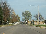
Downtown Suring
-
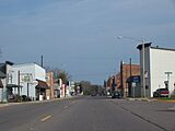
Downtown Suring
-
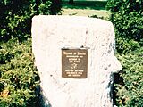
Geographic marker
-
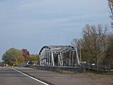
Bridge


See also
 In Spanish: Suring (Wisconsin) para niños
