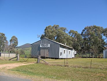
Lankeys Creek, New South Wales facts for kids
Quick facts for kids Lankeys CreekNew South Wales |
|||||||||
|---|---|---|---|---|---|---|---|---|---|

Memorial Hall
|
|||||||||
| Postcode(s) | 2644 | ||||||||
| Elevation | 355–591 m (1,165–1,939 ft) | ||||||||
| Location | |||||||||
| LGA(s) | Greater Hume Shire Council | ||||||||
| County | Goulburn | ||||||||
| State electorate(s) | Albury | ||||||||
|
|||||||||
Lankeys Creek is a small country community located in the eastern part of the Riverina region in Australia. It's about 18 kilometres northwest of Jingellic and 36 kilometres southeast of Holbrook.
A post office used to be open in Lankeys Creek. It first opened for a short time in 1890. Then it reopened in 1906 and finally closed its doors in 1961.
Weather in Lankeys Creek
The Lankeys Creek area is located on the South West Slopes. This means it's one of the first higher areas that westerly winds reach. Because of this, the area often has cooler temperatures, especially in winter.
For example, at the Brookfield Forest Station, the average temperature in July was about 9.9 degrees Celsius. This station was in a pine plantation area, about 457 metres above sea level. It collected weather information from 1938 to 1968.
Temperature and Rainfall Data
The tables below show detailed weather information for two locations near Lankeys Creek. This data helps us understand the typical climate of the area.
| Climate data for Brookfield Forest Station (1938–1968); 457 m AMSL; 35.80° S, 147.93° E | |||||||||||||
|---|---|---|---|---|---|---|---|---|---|---|---|---|---|
| Month | Jan | Feb | Mar | Apr | May | Jun | Jul | Aug | Sep | Oct | Nov | Dec | Year |
| Mean daily maximum °C (°F) | 28.7 (83.7) |
27.7 (81.9) |
24.8 (76.6) |
19.1 (66.4) |
14.5 (58.1) |
10.9 (51.6) |
9.9 (49.8) |
11.8 (53.2) |
15.6 (60.1) |
18.6 (65.5) |
21.8 (71.2) |
26.0 (78.8) |
19.1 (66.4) |
| Mean daily minimum °C (°F) | 10.1 (50.2) |
10.1 (50.2) |
7.5 (45.5) |
3.9 (39.0) |
1.4 (34.5) |
0.2 (32.4) |
−0.8 (30.6) |
0.3 (32.5) |
1.7 (35.1) |
4.0 (39.2) |
6.0 (42.8) |
7.9 (46.2) |
4.4 (39.9) |
| Average precipitation mm (inches) | 56.0 (2.20) |
47.2 (1.86) |
65.5 (2.58) |
65.6 (2.58) |
86.2 (3.39) |
82.3 (3.24) |
99.0 (3.90) |
92.3 (3.63) |
81.6 (3.21) |
98.7 (3.89) |
70.8 (2.79) |
60.1 (2.37) |
906.3 (35.68) |
| Average precipitation days (≥ 0.2 mm) | 6.0 | 5.6 | 6.3 | 8.0 | 10.8 | 12.7 | 13.9 | 14.5 | 10.7 | 11.9 | 8.5 | 7.3 | 116.2 |
| Source: Australian Bureau of Meteorology; Brookfield Forest Station | |||||||||||||
| Climate data for Carabost Forest Headquarters (1938–1969, rainfall 1938–1997); 580 m AMSL; 35.65° S, 147.80° E | |||||||||||||
|---|---|---|---|---|---|---|---|---|---|---|---|---|---|
| Month | Jan | Feb | Mar | Apr | May | Jun | Jul | Aug | Sep | Oct | Nov | Dec | Year |
| Mean daily maximum °C (°F) | 28.0 (82.4) |
27.2 (81.0) |
24.1 (75.4) |
18.7 (65.7) |
13.7 (56.7) |
10.8 (51.4) |
9.1 (48.4) |
10.8 (51.4) |
14.3 (57.7) |
18.0 (64.4) |
21.1 (70.0) |
25.4 (77.7) |
18.4 (65.2) |
| Mean daily minimum °C (°F) | 11.0 (51.8) |
11.2 (52.2) |
9.0 (48.2) |
5.6 (42.1) |
3.2 (37.8) |
1.7 (35.1) |
0.2 (32.4) |
1.7 (35.1) |
3.2 (37.8) |
5.5 (41.9) |
7.0 (44.6) |
9.0 (48.2) |
5.7 (42.3) |
| Average precipitation mm (inches) | 56.4 (2.22) |
48.6 (1.91) |
61.2 (2.41) |
72.6 (2.86) |
96.4 (3.80) |
92.8 (3.65) |
112.5 (4.43) |
107.6 (4.24) |
84.4 (3.32) |
100.1 (3.94) |
70.5 (2.78) |
60.1 (2.37) |
966.5 (38.05) |
| Average precipitation days (≥ 0.2 mm) | 5.1 | 4.7 | 5.4 | 7.0 | 9.7 | 10.7 | 12.6 | 13.0 | 10.1 | 10.1 | 7.8 | 6.2 | 102.4 |
| Source: Australian Bureau of Meteorology; Carabost Forest Headquarters | |||||||||||||


