
Larkin Covered Bridge (Chester Springs, Pennsylvania) facts for kids
Quick facts for kids |
|
|
Larkin Covered Bridge
|
|

Larkin Covered Bridge originally spanned Marsh Creek in Milford Mills, Pennsylvania
|
|

Location in Pennsylvania

Location in the United States
|
|
| Location | Eagle, Upper Uwchlan Township, Pennsylvania |
|---|---|
| Area | less than one acre |
| Built | 1881 (original bridge 1854) |
| Built by | Wood, Menander & Ferdinand |
| Architectural style | Burr truss |
| MPS | Covered Bridges of Chester County TR |
| NRHP reference No. | 80003458 |
| Added to NRHP | December 10, 1980 |
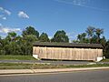
The Larkin Covered Bridge is a special kind of bridge. It is a 60-foot-long (18 m) wooden bridge with a roof and sides, like a tunnel. It uses a strong design called a Burr Truss.
This bridge is located near Chester Springs in Chester County, Pennsylvania. It is close to the small village of Eagle. The bridge used to cross over a stream called Marsh Creek. Now, it goes over a dry ditch and is part of the walking trails in Upper Uwchlan Township.
Contents
The History of Larkin Covered Bridge
Building the First Bridge
The very first bridge at this spot was built in 1854. It was called Wario's Bridge. It crossed over Marsh Creek, which is a small stream that flows into the east branch of the Brandywine Creek. This bridge was next to Jesse Larkin's Gristmill (a mill that grinds grain). It was near the village of Milford Mills. This spot was about 2.5 miles (4.0 km) southwest of where the bridge is today. The bridge was rebuilt in 1881, making it stronger and newer.
Moving the Bridge for a Lake
In 1972, the state government of Pennsylvania bought the Larkin Bridge. They moved it about 1 mile (1.6 km) north. This was done before the village of Milford Mills was cleared out. The area was being prepared to create Marsh Creek Lake inside Marsh Creek State Park.
After being moved, the bridge was used for people to walk across. It connected two different day camps within the new state park. In 1980, the Larkin Bridge was officially added to the National Register of Historic Places. This list recognizes important historical places in the United States.
A New Home for the Bridge
In 1998, Upper Uwchlan Township took ownership of the bridge. Then, in 2006, the township worked with some building companies. They carefully took the bridge apart and moved it again.
The Larkin Covered Bridge was rebuilt on a walking trail. It is now near the entrance to a neighborhood called Byers Station. This area is on Graphite Mine Road, close to the village of Eagle.
Images for kids
-
Larkin Covered Bridge in September 2010

