
Latakia Governorate facts for kids
Quick facts for kids
Latakia Governorate
مُحافظة اللاذقية
|
|
|---|---|
.svg)
Map of Syria with Latakia highlighted
|
|
| Country | |
| Capital | Latakia |
| Manatiq (Districts) | 4 |
| Area | |
| • Total | 2,297 km2 (887 sq mi) |
| Estimates range between 2,297 km² and 2,437 km² | |
| Population
(2014)
|
|
| • Total | 1,890,000 |
| • Density | 822.8/km2 (2,131/sq mi) |
| Time zone | UTC+2 (EET) |
| • Summer (DST) | UTC+3 (EEST) |
| ISO 3166 code | SY-LA |
Latakia Governorate (Arabic: مُحافظة اللاذقية) is one of the fourteen governorates (provinces) in Syria. It is located in western Syria, right next to Turkey. The size of the governorate is about 2,297 square kilometers. In 2014, it had a population of around 1.89 million people.
The capital city of the governorate is also called Latakia. This city is a very important port for Syria.
Contents
Discovering Latakia's Geography

Latakia Governorate shares a border with Turkey to the north. To the south, it borders Tartus. To the east, you'll find Hama and Idlib. The Mediterranean Sea is to its west.
The western part of Latakia Governorate has flat coastal areas. But the eastern parts are very mountainous. The Syrian Coastal Mountain Range runs through this area from north to south. Its highest point is Nabi Yunis, which is 1,562 meters (5,125 feet) tall.
The western mountains get a lot of rain from the Mediterranean Sea. This makes them very fertile and a good place for people to live.
Rivers and Waterways
The Orontes River flows north along the eastern side of the mountains. It goes through a long valley called the Ghab valley. Then it flows around the northern edge of the mountains and into the Mediterranean Sea.
Another important river is Nahr al-Kabir al-Shamali. This river starts near the Turkish border and flows southwest into the Mediterranean. The 16 Tishreen dam was built on this river. It helps create electricity, stores water, and formed the beautiful Mashqita lake.
Latakia's Climate
Latakia Governorate has a Mediterranean climate. This means it has hot, dry summers and mild, wet winters. The coastal areas are generally warmer than the mountains. The mountains receive more rain and can even get some snow in winter.
Cities and Districts
Latakia Governorate is divided into four main areas called districts. Each district has a main city that acts as its center.
Major Cities in Latakia
Here are the main cities in Latakia Governorate and their populations from a 2004 census:
| City | Population |
|---|---|
| Latakia | 383,786 |
| Jableh | 80,000 |
| Qardaha | 8,671 |
| al-Haffa | 4,298 |
Understanding Latakia's Districts
|
Jableh
Qardaha
Al-Haffah
|
The governorate is split into four main districts:
- Al-Haffah
- Jableh
- Latakia
- Qardaha
These districts are further divided into smaller areas called sub-districts.
Latakia's Economy and Tourism

Being on the Mediterranean Sea makes Latakia Governorate very important for trade. The city of Latakia has Syria's main seaport, which opened on February 12, 1950.
Many different goods pass through this port. These include clothes, building materials, vehicles, and furniture. Food items like lentils, onions, wheat, and figs are also imported. In 2008, the port handled about 8 million tons of goods!
Tourism in Latakia
Latakia is also a popular place for Syrian people to visit. The Cote d'Azur Beach is Syria's top coastal resort. Here, visitors can enjoy water skiing, jet skiing, and windsurfing.
The city has several hotels, including some with five-star ratings. Many people enjoy walking around the markets and shopping in Latakia. There are also cinemas like Ugarit Cinema and al-Kindi.
People and Languages
Latakia Governorate is home to different groups of people. The largest group are the Alawites. There are also Armenians, Turkmen, and Kurds.
In 2010, the city of Latakia had a mix of people. About 50% were Alawites, 40% were Sunni Muslims, and 10% were Christians. In the countryside, about 70% of people are Alawites. Christians make up about 14%, and Sunni Muslims about 12%.
Christians are the majority in the northern town of Kessab. They also live in many neighborhoods in Latakia city.
Languages Spoken in Latakia
The main languages spoken in the province are Arabic, Armenian, and Turcoman.
- Arabic is spoken in most towns and villages. The North Levantine Arabic dialect is commonly used.
- Armenian is the main language in Kessab, a town with a long Armenian history. It is also spoken in nearby villages.
- Turcoman is spoken mainly in the Turkmen Mountain area.
While there is a Kurdish minority, most of them now speak Arabic. However, some still speak the Kurmanji dialect of Kurdish, especially in Jabal al-Akrad.
Images for kids
-
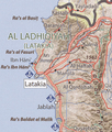
Map of Latakia governorate
-
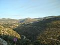
Mountains near Beit Yashout
-
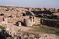
Ruins of Ugarit
-
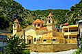
Armenian church in Kessab
-
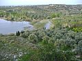
Countryside near Mushayrafet al-Samouk
-
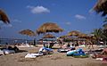
Sunbathers on the Latakian Cote d'Azur


See also
 In Spanish: Gobernación de Latakia para niños
