Laurel Bay, South Carolina facts for kids
Quick facts for kids
Laurel Bay, South Carolina
|
|
|---|---|

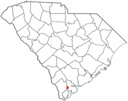
Location of Laurel Bay, South Carolina
|
|
| Country | United States |
| State | South Carolina |
| County | Beaufort |
| Area | |
| • Total | 5.05 sq mi (13.09 km2) |
| • Land | 4.16 sq mi (10.79 km2) |
| • Water | 0.89 sq mi (2.30 km2) |
| Elevation | 36 ft (11 m) |
| Population
(2020)
|
|
| • Total | 5,082 |
| • Density | 1,220.46/sq mi (471.19/km2) |
| Time zone | UTC-5 (Eastern (EST)) |
| • Summer (DST) | UTC-4 (EDT) |
| ZIP code |
29906
|
| Area code(s) | 843, 854 |
| FIPS code | 45-40525 |
| GNIS feature ID | 1227789 |
Laurel Bay is a special kind of community in Beaufort County, South Carolina, United States. It's known as a census-designated place, which means it's an area that the government counts as a town for population numbers, even if it's not officially a city. Laurel Bay is mostly a place where military families live.
In 2010, about 5,891 people lived here. It's part of a larger area that includes Hilton Head Island and Bluffton.
Laurel Bay is mainly home to military members and their families. These families work at nearby military bases. Some of these bases include MCAS Beaufort, MCRD Parris Island, and USNH Beaufort. The housing area in Laurel Bay first opened in the mid-1950s.
History of Laurel Bay
A historic place called Chester Field is located within the Laurel Bay housing area. It was added to the National Register of Historic Places in 1970. This means it's an important site recognized for its history.
In the past, homes in Laurel Bay used underground tanks for heating oil. These tanks were later removed, starting in 2007. During this process, some heating oil was released into the ground. The Marine Corps has done tests in the area to make sure everything is safe. So far, the tests show that the soil gas levels are within safe limits. Also, information from the South Carolina Department of Health and Environmental Control (SC DHEC) shows that the area does not have a higher rate of certain health issues.
Where is Laurel Bay?
Laurel Bay is located in South Carolina. You can find it at these coordinates: 32°27′28″N 80°47′26″W / 32.45778°N 80.79056°W.
The United States Census Bureau says that Laurel Bay covers about 14.0 square kilometers (about 5.4 square miles). Most of this area is land, about 11.7 square kilometers (4.5 square miles). The rest, about 2.3 square kilometers (0.9 square miles), is water.
Who Lives in Laurel Bay?
| Historical population | |||
|---|---|---|---|
| Census | Pop. | %± | |
| 2020 | 5,082 | — | |
| U.S. Decennial Census | |||
According to the census from 2000, there were 6,625 people living in Laurel Bay. There were 1,888 households, which are like homes or families living together.
Many of the households in Laurel Bay had children under 18 living with them. The average household had about 3.5 people.
The population in Laurel Bay is quite young. In 2000, about 42.8% of the people were under 18 years old. The average age of people living there was 23 years. This shows that many young families with children live in this military community.
See also
 In Spanish: Laurel Bay para niños

