Lawrenceville, Ohio facts for kids
Quick facts for kids
Lawrenceville, Ohio
|
|
|---|---|

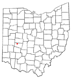
Location of Lawrenceville, Ohio
|
|

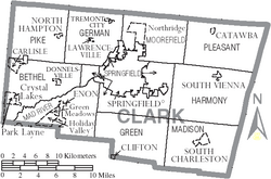
Detailed map of Clark County showing Lawrenceville's location
|
|
| Country | United States |
| State | Ohio |
| County | Clark |
| Area | |
| • Total | 0.49 sq mi (1.27 km2) |
| • Land | 0.49 sq mi (1.27 km2) |
| • Water | 0.00 sq mi (0.00 km2) |
| Elevation | 1,106 ft (337 m) |
| Population
(2020)
|
|
| • Total | 667 |
| • Density | 1,358.45/sq mi (524.42/km2) |
| Time zone | UTC-5 (Eastern (EST)) |
| • Summer (DST) | UTC-4 (EDT) |
| FIPS code | 39-42210 |
| GNIS feature ID | 2805296 |
Lawrenceville is a small community located in Clark County, Ohio, United States. It is an unincorporated community, which means it doesn't have its own local government like a city or town. Instead, it's governed by the county. Lawrenceville is also a census-designated place, a special area defined by the government for counting people during the census. It is part of the larger Springfield, Ohio metropolitan area. In 2000, Lawrenceville was a village with 302 people. However, in 2005, residents voted to change its status, so it is no longer a village.
Contents
The Story of Lawrenceville
Lawrenceville was first known as Noblesville. It was officially planned and marked on a map, a process called platting, in 1843. The name had to be changed because there was another post office in Ohio with a similar name.
How Lawrenceville Got Its Name
A post office called Lawrenceville was opened in 1875. It stayed in operation until 1901. The community was named "Lawrenceville" to honor William Lawrence, a U.S. Representative. He was a Republican and a former judge whose area in Congress included this community during the 1870s.
Where is Lawrenceville Located?
Lawrenceville is found in central German Township, within Clark County, Ohio. According to the United States Census Bureau, the community covers a total area of about 0.49 square miles (1.27 square kilometers). All of this area is land.
Who Lives in Lawrenceville?
The census helps us understand the population of a place. In 2020, the population of Lawrenceville was 667 people.
Population Changes Over Time
| Historical population | |||
|---|---|---|---|
| Census | Pop. | %± | |
| 2020 | 667 | — | |
| U.S. Decennial Census | |||
In the year 2000, there were 302 people living in Lawrenceville. These people lived in 109 households, and 86 of these were families. The community had about 2,243 people per square mile (866 people per square kilometer). There were 119 housing units, which are homes or apartments.
Community Makeup in 2000
Most of the people in Lawrenceville in 2000 were White (95.36%). A small percentage were African American (0.99%), and 3.64% were from two or more racial backgrounds.
Out of the 109 households, about 35.8% had children under 18 living there. Many households (61.5%) were married couples living together. About 11.0% had a female head of household with no husband present. Around 21.1% were non-family households. About 16.5% of all households were made up of individuals living alone, and 3.7% of these were people aged 65 or older. On average, there were 2.77 people per household and 3.12 people per family.
Age and Income in 2000
The population was spread out by age. About 29.1% were under 18 years old. Around 7.6% were between 18 and 24. The largest group, 30.5%, was between 25 and 44. About 23.5% were between 45 and 64, and 9.3% were 65 years or older. The average age in Lawrenceville was 36 years.
The average income for a household in Lawrenceville was $50,000. For families, the average income was $53,750. The per capita income for the community was $19,105. About 3.7% of families and 3.1% of the total population lived below the poverty line. This included no one under 18, but 20.0% of those aged 65 or older.
 | Bayard Rustin |
 | Jeannette Carter |
 | Jeremiah A. Brown |

