Laye facts for kids
Quick facts for kids
Laye
|
||
|---|---|---|

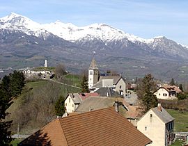
The church and the surrounding buildings in Laye
|
||
|
||
| Country | France | |
| Region | Provence-Alpes-Côte d'Azur | |
| Department | Hautes-Alpes | |
| Arrondissement | Gap | |
| Canton | Saint-Bonnet-en-Champsaur | |
| Intercommunality | Champsaur | |
| Area
1
|
10.55 km2 (4.07 sq mi) | |
| Time zone | UTC+01:00 (CET) | |
| • Summer (DST) | UTC+02:00 (CEST) | |
| INSEE/Postal code |
05072 /05500
|
|
| Elevation | 976–2,158 m (3,202–7,080 ft) (avg. 1,200 m or 3,900 ft) |
|
| 1 French Land Register data, which excludes lakes, ponds, glaciers > 1 km2 (0.386 sq mi or 247 acres) and river estuaries. | ||
Laye is a small commune located in the Hautes-Alpes department in southeastern France. A commune is like a small town or village area. The Hautes-Alpes department is known for its beautiful mountains, as it's part of the French Alps.
About Laye
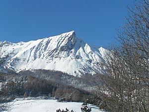
Laye is a charming place nestled in the Champsaur valley. It's surrounded by stunning natural landscapes. The village itself sits at an elevation of about 1,200 meters (around 3,900 feet) above sea level. The highest point in the commune reaches 2,158 meters (over 7,000 feet). This makes Laye a great spot for enjoying mountain views and outdoor activities.
People Living in Laye
The number of people living in Laye has changed over the years. In 1962, there were 125 residents. By 1999, the population had grown to 212 people. In 2008, about 231 people called Laye home. This shows that Laye is a small community, but it has seen some growth over time.
Getting Around Laye
Roads and Travel
Several roads help people travel to and from Laye. These include the D14, D88, D217A, and N85. These roads connect Laye to other towns and villages in the region. They are important for residents to get to schools, shops, and other services. They also allow visitors to explore the beautiful Champsaur valley and the surrounding mountains.
 | Roy Wilkins |
 | John Lewis |
 | Linda Carol Brown |


