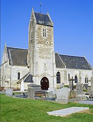
Le Locheur facts for kids
Quick facts for kids
Le Locheur
|
|
|---|---|
|
Part of Val d'Arry
|
|

Saint-Jacques
|
|
| Country | France |
| Region | Normandy |
| Department | Calvados |
| Arrondissement | Caen |
| Canton | Les Monts d'Aunay |
| Commune | Val d'Arry |
| Area
1
|
3.68 km2 (1.42 sq mi) |
| Population
(2020)
|
250 |
| • Density | 67.9/km2 (176/sq mi) |
| Time zone | UTC+01:00 (CET) |
| • Summer (DST) | UTC+02:00 (CEST) |
| Postal code |
14210
|
| Elevation | 50–131 m (164–430 ft) |
| 1 French Land Register data, which excludes lakes, ponds, glaciers > 1 km2 (0.386 sq mi or 247 acres) and river estuaries. | |
Le Locheur was a small village, also known as a "commune," located in northwestern France. It was part of the Calvados area in the Normandy region. On January 1, 2017, Le Locheur joined with other nearby villages to form a new, larger commune called Val d'Arry. This means Le Locheur is no longer a separate commune on its own.
Where Was Le Locheur?
Le Locheur was situated in the Calvados department. This department is part of the Normandy region, which is famous for its history and beautiful landscapes. The village was located in the northwestern part of France.
How Many People Lived in Le Locheur?
The number of people living in Le Locheur changed over the years. Here's a look at its population at different times:
- 1962: 177 people
- 1968: 188 people
- 1975: 183 people
- 1982: 186 people
- 1990: 242 people
- 1999: 280 people
- 2008: 276 people
- 2020: 250 people
As you can see, the population grew from the 1960s to the late 1990s, reaching its highest point in 1999. By 2020, just a few years after it merged into Val d'Arry, about 250 people lived in the area that used to be Le Locheur.
What Is a Commune?
In France, a "commune" is the smallest unit of local government. Think of it like a town or a small district. Each commune has its own local council and mayor, who help manage things like local services and public spaces. When communes merge, like Le Locheur did, they combine their resources and administration to work together as one larger unit.
See Also

- In Spanish: Le Locheur para niños
 | Selma Burke |
 | Pauline Powell Burns |
 | Frederick J. Brown |
 | Robert Blackburn |


