
Le Saix facts for kids
Quick facts for kids
Le Saix
|
|
|---|---|

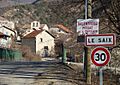
The entrance to the village in Le Saix
|
|

Le Saix
Location in France

Le Saix
Location in Provence-Alpes-Côte d'Azur
|
|
| Country | France |
| Region | Provence-Alpes-Côte d'Azur |
| Department | Hautes-Alpes |
| Arrondissement | Gap |
| Canton | Serres |
| Area
1
|
22.15 km2 (8.55 sq mi) |
| Population
(Jan. 2019)
|
117 |
| • Density | 5.282/km2 (13.68/sq mi) |
| Time zone | UTC+01:00 (CET) |
| • Summer (DST) | UTC+02:00 (CEST) |
| INSEE/Postal code |
05158 /05400
|
| Elevation | 774–1,830 m (2,539–6,004 ft) (avg. 813 m or 2,667 ft) |
| 1 French Land Register data, which excludes lakes, ponds, glaciers > 1 km2 (0.386 sq mi or 247 acres) and river estuaries. | |
Le Saix is a small village in the Hautes-Alpes area of France. It is known as a commune, which is like a local government area. This peaceful place is located in the southeastern part of France.
Contents
All About Le Saix
Le Saix is a charming commune found in the Hautes-Alpes department. This department is part of the Provence-Alpes-Côte d'Azur region. The village is nestled among mountains, offering beautiful views.
Where is Le Saix?
Le Saix is located in the Arrondissement of Gap. It is also part of the Canton of Serres. These are ways that France divides its areas for local government. The village sits at an average height of 813 meters above sea level. Its highest point is 1830 meters, and its lowest is 774 meters.
How Many People Live Here?
Le Saix is a very small commune. In January 2019, about 117 people lived there. The number of people living in Le Saix has changed over the years. For example, in 1962, there were 72 residents, and by 1999, it had grown to 79. The population has seen small ups and downs, but it remains a quiet community.
Getting Around Le Saix
Several roads help people travel through the commune of Le Saix. These include the D49, D49A, and D249T roads. These roads connect the village to other nearby areas. They are important for residents and visitors to move around.
Images for kids
-
The entrance to the village of Le Saix.
See also
 In Spanish: Le Saix para niños
