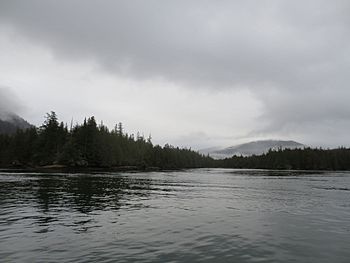
Lelu Island (British Columbia) facts for kids
|
Native name:
Lax U’u’la
|
|
|---|---|

The North End of Lax U’u’la in Winter
|
|
| Geography | |
| Coordinates | 54°11′59″N 130°17′19″W / 54.19972°N 130.28861°W |
Lelu Island is an island located in British Columbia, Canada. It sits in the Skeena Estuary, which is where the Skeena River meets the ocean. The island is found between Smith and Ridley Islands. For a very long time, First Nations people have lived on and used this island.
Right next to Lelu Island, there's a special underwater area called the Flora Bank. This area is very important because it provides a critical home for many fish.
Proposed Natural Gas Project
In 2013, a company called Petronas suggested building a large facility on Lelu Island. This facility would be used to export liquefied natural gas (LNG). LNG is natural gas that has been cooled down to a liquid form. This makes it easier to transport.
Community Opposition
Many people, especially members of the Lax Kw'alaams Nation, were against this project. In September 2015, some members of the Lax Kw'alaams Nation set up a camp on the island. They did this to show their strong opposition to the proposed facility.
In April 2016, the Prince Rupert Port Authority asked them to stop building their camp. However, the Lax Kw'alaams Nation members continued their protest.
Project Approval and Abandonment
In September 2016, the Canadian government approved the project. They gave it 190 conditions that the company had to follow. Even with this approval, the Lax Kw'alaams Nation members kept their camp and continued to oppose the project.
The project had faced a lot of debate. The Lax Kw'alaams First Nation had voted against it at one point. Later, their mayor, John Helin, supported it, but many hereditary chiefs still opposed it. The Premier of British Columbia, Christy Clark, also supported the project.
However, on July 25, 2017, Petronas announced they would not go ahead with the facility. They decided to stop the project because of market conditions and the ongoing opposition.
 | Delilah Pierce |
 | Gordon Parks |
 | Augusta Savage |
 | Charles Ethan Porter |


