Levern Water facts for kids
Quick facts for kids Levern Water |
|
|---|---|

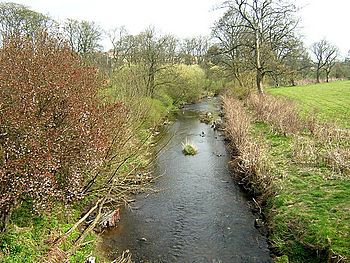
Levern Water pictured near Househillwood
|
|
| Country | Scotland |
| Physical characteristics | |
| Main source | Long Loch (East Renfrewshire) |
| River mouth | White Cart River Glasgow, Scotland 55°50′11″N 4°21′45″W / 55.83651°N 4.36240°W |
The Levern Water is a small river in East Renfrewshire and Glasgow, Scotland. Its name in Scottish Gaelic is Uisge Labharain. This river starts in the Long Loch and flows mostly north and east. It passes by the towns of Neilston and Barrhead. The Levern Water is about 9 miles (14.5 km) long. It eventually flows into the White Cart River.
For a long time, the Levern Water was very important for the growth of towns in East Renfrewshire. It provided water power for cotton mills and helped homes get the energy they needed.
Contents
Where Does Levern Water Flow?
The Levern Water begins at the north-eastern end of Long Loch in East Renfrewshire. From there, it flows north-west for a short distance.
Harelaw Dam and Reservoirs
The river then enters a large reservoir. This reservoir covers about 41 hectares (101 acres). It was created by four parts of the Harelaw Dam. The dam was built in 1844 and is now used for trout fishing.
After Harelaw Dam, the river continues west to a smaller reservoir called Commore Dam. From Commore Dam, the Levern Water flows directly north. It then slowly turns towards the north-east.
Journey Through Towns
The river flows past Neilston, staying to the west and north of the town. From Neilston, it continues east towards Barrhead. After leaving Barrhead, the river heads north-east.
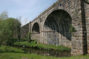
For a while, the Levern Water forms the border between East Renfrewshire and the city of Glasgow. It crosses under the Glasgow South Western Line railway at the Levern Water viaduct. The river then fully enters Glasgow near Nitshill. Here, it also crosses under the A726 dual-carriageway.
Joining the White Cart River
The Levern Water continues flowing past the suburb of Pollok. Finally, it joins the White Cart River near Crookston Castle. This castle is famous because Mary, Queen of Scots went there after the Battle of Langside in 1568.
The Levern Water Viaduct
In 1847, a railway company called the Glasgow, Barrhead and Neilston Direct Railway built a large bridge over the Levern Water. This bridge is called a viaduct. It has three arches and was designed by an engineer named Neil Robson from Glasgow.
The viaduct was built using strong, rough-cut stone blocks. Since February 17, 1992, this viaduct has been recognized as a Category B historic site in Scotland.
Salterland Road Bridge
Right next to the railway viaduct, there is a smaller bridge. This bridge carries the local Salterland Road over the Levern Water. It has two arches and was built in the 18th century. This older bridge is also listed as a Category C historic site.
 | Chris Smalls |
 | Fred Hampton |
 | Ralph Abernathy |


