River Cart facts for kids
Quick facts for kids River Cart |
|
|---|---|
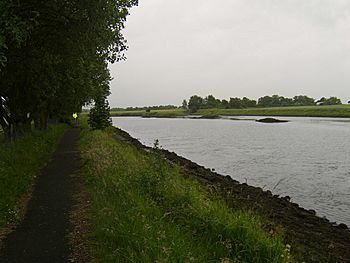
River Cart, looking south
|
|
| Country | Scotland |
| Physical characteristics | |
| River mouth | River Clyde Glasgow, Scotland 55°53′30″N 4°24′18″W / 55.8917°N 4.4049°W |
The River Cart (also called River Cairt in Scots) is a short river in Scotland. It flows into the River Clyde from the west. This happens between the towns of Erskine and Renfrew, across from Clydebank.
The River Cart itself is very short. It forms where two other rivers meet: the Black Cart Water and the White Cart Water. The Black Cart Water comes from the west. The White Cart Water comes from the south east. The main River Cart is only about 1.2 kilometers (0.75 miles) long.
Long ago, the River Cart and the White Cart Water could be used by boats. They were navigable up to Paisley. People made changes to the river to help boats travel more easily.
In 1840, a short canal called the Forth and Cart Canal opened. It was about 800 meters (0.5 miles) long. This canal connected to the Forth and Clyde Canal near Clydebank. Its goal was to create a direct water route. This route would link Paisley with places like Edinburgh and the Firth of Forth.
Contents
Black Cart Water: The Western Branch
The Black Cart Water (or Black Cairt Watter in Scots) starts at Castle Semple Loch in Lochwinnoch. This area is in Renfrewshire. From there, it flows towards the northeast. It passes through the town of Johnstone. Then it goes past Linwood.
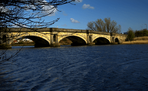
The river then flows under the M8 motorway. Near Blackstoun, another river, the River Gryfe, joins it. The Black Cart Water then runs next to the main runway of Glasgow International Airport. It passes under the A8 road at Renfrew. Here, it goes under an old stone bridge. Finally, it meets the White Cart Water, forming the River Cart.
White Cart Water: The Eastern Branch
The White Cart Water (or White Cairt Watter in Scots) begins on the edge of East Renfrewshire. It starts in the middle of Eaglesham Moor. It then flows north, south of East Kilbride, to Waterfoot. Here, the Earn Water joins it. This part of the river forms a border between East Renfrewshire and South Lanarkshire.
The river then flows through the village of Busby. It passes under a large railway bridge. After this, the Thorntonhall Burn and Kittoch Water join it. Kittoch Water is an important river from East Kilbride. The White Cart Water then becomes a border again. It runs around the eastern side of Clarkston and Netherlee.
There are old woodlands along the river near Busby. There is also a large special nature area (SSSI) for an even bigger ancient woodland. This woodland is on the east bank past Clarkston and Netherlee. This area ends when the river enters Glasgow city. It flows into Linn Park and then to Cathcart.
Here, the river turns west. It flows through areas like Battlefield, Langside, Shawlands, and Pollokshaws. Then it reaches Auldhouse. Here, the Auldhouse Burn joins it.
The river then flows through Pollok Country Park. It passes under the M77 motorway at Pollok. It continues towards Crookston and Cardonald. Here, the Levern Water joins it. From Crookston, the river passes Leverndale Hospital. It then enters Renfrewshire. It flows through farmlands near Hawkhead, next to the old Paisley Canal railway.
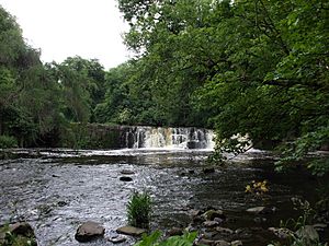
When it reaches Paisley, the river goes over some fast-flowing parts called the Hammils. It flows under two roads and appears in the town center near Paisley Abbey. It then goes under Gauze Street and the Piazza Shopping Centre. It also passes under Paisley Gilmour Street railway station. It comes out from under the Abercorn Bridge. This is a wide, high red sandstone bridge. From there, it mostly flows out of sight towards Glasgow International Airport and Renfrew.
In Paisley, several smaller streams join the White Cart. These include the Lady Burn and the Espedair Burn. Near Glasgow Airport, the Abbot's Burn also joins the river. The Greenock Road (A8) crosses the White Cart Water using a special bridge called the Swing Bridge. Just after this bridge, the White Cart Water joins the Black Cart Water. This is where the River Cart officially begins.
The famous Scottish poet Robert Burns mentioned the White Cart Water in his poem The Gallant Weaver.
To protect homes from floods, Glasgow City Council built a large flood protection system. This project was one of the biggest flood prevention efforts in Scotland at the time.
Medieval Uses of the River
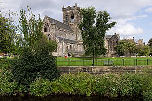
Paisley Abbey had a hidden drain from the Middle Ages. This drain was part of the monastery. It was found again in the 1990s and studied by archaeologists.
This old drain connected to the White Cart Water both upstream and downstream of the abbey. The river provided fresh water for the monastery. It was also used to wash away waste from the kitchens and latrines.
The River Cart and the White Cart Water were once used by boats to reach Paisley. This navigation was stopped in the 1960s. It was blocked near Sneddon Street by a structure under the Piazza Shopping Centre.
Early Improvements for Boats
In 1753, a law called the Paisley Beer Duties Act was passed. This law added a small tax on beer sold in Paisley. The money from this tax was used to improve the River Cart for boats.
Another law was passed in 1787 to help improve the river. This was because shipbuilders in Paisley wanted better access. These efforts led to some improvements around Inchinnan. The first steamer boat service to Paisley started in July 1815. It was called the Prince of Orange.
The first Swing Bridge at Inchinnan opened in 1838. This bridge was on the main road, now the A8. Its moving parts were made by a company in Paisley. A year before, a railway line opened between Paisley and Renfrew. This railway was meant to help river travel and also compete with it.
Modern Improvements and Changes
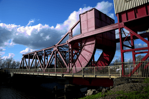
The old swing bridge at Renfrew was replaced in 1923. A new type of bridge, called a bascule bridge, was built by Sir William Arrol & Company. This bridge can still open today. This is important because the Doosan Babcock factory in Renfrew sometimes needs to move very large items by river. During World War II, the first American soldiers to arrive in the UK landed by ship at Carlile Quay in Paisley.
Sir William Arrol and Co also built a pedestrian bridge at Carlile Quay. This bridge could lift up for boats. However, it has not been able to lift for over 30 years. It has been closed to people since 1997 because it is not safe.
In 1938, a new law helped build a harbour at Laigh Park. This harbour was designed for large cargo ships to load and unload goods. It was connected to the Paisley and Renfrew Railway. This harbour was used a lot during World War II. Carlile Quay was used for smaller boats. The lights that guide boats on the river were also made better.
The Laigh Park harbour was no longer used in the 1960s. For many years, it was used as a scrapyard. Carlile Quay has been cleaned up and made nicer for people. New apartments and houses have been built nearby.
Cleaning Up the River
For a long time, all of Paisley's sewage and factory waste went straight into the River Cart. This happened through smaller streams like the St Mirin Burn. By 1870, there were many complaints about bad smells and diseases.
To help, special sewers were built. These sewers collected the waste and sent it directly into the White Cart Water. This helped clean up Paisley itself. However, it did not clean up the main River Cart. Other towns like Johnstone and Glasgow complained. They wanted Paisley to build a sewage treatment plant. Johnstone, Bridge of Weir, Lochwinnoch, and Glasgow already had such plants. Glasgow's plant started working in 1894.
Land was bought for a sewage treatment plant in Paisley between the two World Wars. Construction started in 1949, and the plant opened in 1952. This plant collected all of Paisley's sewage and industrial waste for treatment.
River Power: Watermills
Both the Black Cart Water and the White Cart Water were used to power mills. These mills used the force of the water to turn machinery. The best-preserved mill on the White Cart is Dripps Mill in Waterfoot. It still has two working waterwheels from the 1800s.
 | Chris Smalls |
 | Fred Hampton |
 | Ralph Abernathy |


