Renfrewshire facts for kids
Quick facts for kids
Renfrewshire
Siorrachd Rinn Friù
|
|||
|---|---|---|---|
 |
|||
|
|||
| Sovereign state | United Kingdom | ||
| Country | Scotland | ||
| Lieutenancy area | Renfrewshire | ||
| Admin HQ | Paisley | ||
| Government | |||
| • Body | Renfrewshire Council | ||
| Area | |||
| • Total | 101.0 sq mi (261.5 km2) | ||
| Area rank | Ranked 24th | ||
| Population
(2020)
|
|||
| • Total | 177,790 | ||
| • Rank | Ranked 10th | ||
| • Density | 1,760.9/sq mi (679.89/km2) | ||
| ONS code | S12000038 | ||
| ISO 3166 code | GB-RFW | ||
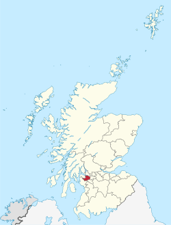
Renfrewshire is one of the 32 areas in Scotland that has its own local government, called a council area. It is located in the west of Scotland, near the River Clyde. The main town and administrative center of Renfrewshire is Paisley. The historic town of Renfrew is also part of this area.
The name Renfrewshire comes from an older area called the historic county of Renfrewshire. This older county was much bigger. Today, the modern Renfrewshire council area covers only the central part of that historic county. The eastern part is now East Renfrewshire, and the western part is Inverclyde.
These three areas – Renfrewshire, Inverclyde, and East Renfrewshire – are sometimes called "Greater Renfrewshire." They work together for some things, like registering voters and valuing properties for local taxes.
Contents
- What Does the Name Renfrewshire Mean?
- A Brief History of Renfrewshire
- Towns and Villages in Renfrewshire
- Local Communities in Renfrewshire
- Who Lives in Renfrewshire?
- Culture and Fun Places to Visit
- How Renfrewshire is Governed
- Learning and Education in Renfrewshire
- Getting Around Renfrewshire: Transport
- Places of Interest to Explore
- See also
What Does the Name Renfrewshire Mean?
The name Renfrewshire comes from the town of Renfrew. This town was once a royal burgh, which is a special type of town in Scotland. The word "shire" means an area controlled by a sheriff, who was like a local judge and administrator.
The name Renfrew itself is very old, going back to Roman times. It is thought to come from an ancient language called Common Brittonic or Cumbric. It likely means "a point of land near the flow of water." This makes sense because Renfrew is located where the Cart and Clyde rivers meet.
A Brief History of Renfrewshire
The historic county of Renfrewshire was changed for local government in 1975. It was split into three smaller areas called districts: Eastwood, Inverclyde, and Renfrew. These districts were part of a larger region called Strathclyde.
Later, in 1996, the local government system changed again. The government wanted to create new council areas. At first, they suggested two new areas: "West Renfrewshire" and "East Renfrewshire." However, people living in these areas and their representatives disagreed with these plans. For example, Inverclyde wanted to be its own separate council area.
Because of these discussions, the plans changed. Inverclyde became its own council area. The central district was then named Renfrewshire. This new Renfrewshire council area covers most of the old Renfrew district. However, some parts, like Barrhead and Neilston, became part of East Renfrewshire. These new council areas officially started on April 1, 1996.
A fun fact about boundaries: In 1999, the Braehead shopping center was built right on the border between Renfrewshire and Glasgow. This caused a disagreement between the two councils about which area the center belonged to. In 2002, the boundary was officially changed so that the entire shopping center is now in Renfrewshire.
Towns and Villages in Renfrewshire
Here are some of the largest towns and villages in Renfrewshire, listed by how many people live there:
| Settlement | Population (2020) |
|---|---|
| Paisley | 77270 |
| Renfrew | 24270 |
| Johnstone | 15930 |
| Erskine | 15010 |
| Linwood | 8450 |
| Bishopton | 7920 |
| Houston | 6360 |
| Elderslie | 5480 |
| Bridge of Weir | 4920 |
| Kilbarchan | 3300 |
Local Communities in Renfrewshire
Renfrewshire is divided into 25 community council areas. These areas help local people have a say in what happens in their neighborhoods. As of 2023, 20 of these areas have active community councils. They are marked with an asterisk (*) below:
- Bishopton*
- Bridge of Weir*
- Brookfield*
- Charleston
- Elderslie*
- Erskine*
- Ferguslie*
- Foxbar and Brediland
- Gallowhill
- Glenburn
- Hawkhead and Lochfield*
- Houston*
- Howwood*
- Hunterhill
- Inchinnan*
- Johnstone*
- Kilbarchan*
- Langbank*
- Linwood*
- Lochwinnoch*
- Paisley East and Whitehaugh*
- Paisley North*
- Paisley West and Central*
- Ralston*
- Renfrew*
Who Lives in Renfrewshire?
Here's a look at the different ethnic groups living in Renfrewshire, based on recent census information:
| Ethnic Group | 2001 | 2011 | 2022 | |||
|---|---|---|---|---|---|---|
| Number | % | Number | % | Number | % | |
| White: Total | 170,728 | 98.76% | 170,127 | 97.27% | 171,816 | 94.78% |
| White: Scottish | 161,395 | 93.36% | 159,708 | 91.31% | 147,073 | 81.13% |
| White: Other British | 5,956 | 3.45% | 5,805 | 3.32% | 12,959 | 7.15% |
| White: Irish | 1,877 | 1.09% | 1,643 | 0.94% | 1,290 | 0.71% |
| White: Gypsy/Traveller | – | – | 70 | – | 70 | – |
| White: Polish | – | – | 1,298 | 0.74% | 5,568 | 3.07% |
| White: Other | 1,500 | 0.87% | 1,603 | 0.92% | 4,853 | 2.68% |
| Asian, Asian Scottish or Asian British: Total | 1,509 | 0.87% | 3,110 | 1.78% | 5,056 | |
| Asian, Asian Scottish or Asian British: Indian | 461 | 0.27% | 1,028 | 0.59% | 1,315 | 0.73% |
| Asian, Asian Scottish or Asian British: Pakistani | 497 | 0.29% | 965 | 0.55% | 2,338 | 1.29% |
| Asian, Asian Scottish or Asian British: Bangladeshi | 8 | – | 19 | – | 45 | – |
| Asian, Asian Scottish or Asian British: Chinese | 440 | 0.25% | 823 | 0.47% | 810 | 0.45% |
| Asian, Asian Scottish or Asian British: Asian Other | 103 | 0.06% | 275 | 0.16% | 548 | 0.30% |
| Black, Black Scottish or Black British | 30 | – | – | – | – | – |
| African: Total | 113 | 0.07% | 804 | 0.46% | 1,439 | 0.79% |
| African: African, African Scottish or African British | – | – | 782 | 0.45% | 165 | 0.09% |
| African: Other African | – | – | 22 | – | 1,274 | 0.70% |
| Caribbean or Black: Total | – | – | 119 | 0.07% | 163 | 0.09% |
| Caribbean | 54 | – | 64 | – | 68 | – |
| Black | – | – | 47 | – | 15 | – |
| Caribbean or Black: Other | – | – | 8 | – | 80 | – |
| Mixed or multiple ethnic groups: Total | 285 | 0.16% | 437 | 0.25% | 1,912 | 1.05% |
| Other: Total | 148 | 0.09% | 311 | 0.18% | 888 | 0.49% |
| Other: Arab | – | – | 194 | 0.11% | 329 | 0.18% |
| Other: Any other ethnic group | – | – | 117 | 0.07% | 559 | 0.31% |
| Total: | 172,867 | 100.00% | 174,908 | 100.00% | 181,278 | 100.00% |
Culture and Fun Places to Visit
Renfrewshire has many interesting places to explore. If you love nature, you can visit Castle Semple Loch in Lochwinnoch. This area is part of the larger Clyde Muirshiel Regional Park. The Gleniffer Braes country park in the south is also a beautiful natural spot.
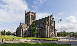
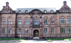
In Paisley, there are many historic buildings and famous sites. You can see Paisley Abbey, which is a very old church. There's also the Paisley Museum and Coats Observatory, where you can learn about history and look at the stars. Other notable places include Paisley Town Hall, Coats Memorial Church, and Sma' Shot Cottages. If you like football, you can visit St Mirren F.C.'s home ground, St Mirren Park.
Outside of Paisley, the village of Elderslie is said to be the birthplace of the Scottish hero William Wallace. There's a monument there to honor him. In Kilbarchan, you can visit the Weaver's Cottage, which is looked after by the National Trust for Scotland. The town of Johnstone has Johnstone Castle and a unique museum inside a supermarket!
For sports fans, the Braehead Arena is a great place. It's home to the Scottish Rocks, a professional basketball team. The arena also hosted the World Curling Championships in 2000.
How Renfrewshire is Governed
Renfrewshire is run by the Renfrewshire Council. This council is made up of elected representatives who make decisions about local services. These services include things like schools, roads, libraries, and waste collection. The council works to improve the lives of people living in Renfrewshire.
Learning and Education in Renfrewshire
Renfrewshire is home to the University of the West of Scotland (UWS). This university started as a technical college in Paisley and became a university in 1992. In 2007, it merged with another college and became UWS. While it has campuses in other parts of Scotland, its main campus is still in Paisley.
For students who want to continue their education after high school but not go to university, there's the Paisley Campus of West College Scotland. This college helps about 20,000 students learn new skills.
Renfrewshire has many schools for children and teenagers. There are eleven state secondary schools, including Paisley Grammar School. It also has 51 primary schools and three special schools for children who need extra support with their learning.
Getting Around Renfrewshire: Transport
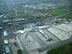
Renfrewshire is a busy place for travel because it has Glasgow International Airport. This is Scotland's second busiest airport and is located between Paisley and Renfrew.
The airport is connected by the M8 motorway, a major road that helps people travel across Scotland. The Erskine Bridge is also a key part of the transport network, connecting different areas.
To make travel easier, there have been improvements over the years. For example, tolls (fees) were removed from the Erskine Bridge. There are also plans to improve public transport, like a possible new metro line connecting Paisley, the airport, and Glasgow. Bus services are also available from companies like FirstGroup and McGill's Bus Services.
Places of Interest to Explore
- Auchenbathie Tower
- Barr Castle
- Barshaw Park
- Belltrees Peel
- Castle Semple Church
- Castle Semple Loch Peel Tower
- Climbzone
- Clyde Muirshiel Regional Park
- Coats Observatory
- Coats Paisley
- Craigends Yew
- Craigie Linn waterfall
- Erskine Bridge
- Fountain Gardens, Paisley
- Gleniffer Braes
- Johnstone Castle
- Kenmure Hill Temple
- Lagoon Leisure Centre
- Meikle Millbank Mill
- Paisley Abbey
- Paisley Museum and Art Galleries
- Paisley Thread Mill Museum
- Paisley Town Hall
- Ranfurly Castle
- Renfrew Museum
- Robertson Park
- Sma' Shot Cottages
- St Fillan's Kirk, Seat and Well
- St Matthew's Church, Paisley
- St Patrick's Rock
- St Peter's Well, Houston
- Windy Hill
- Weaver's Cottage
See also
 In Spanish: Renfrewshire para niños
 | Janet Taylor Pickett |
 | Synthia Saint James |
 | Howardena Pindell |
 | Faith Ringgold |


