Libertyville, Indiana facts for kids
Quick facts for kids
Libertyville, Indiana
|
|
|---|---|

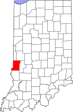
Vigo County's location in Indiana
|
|
| Country | United States |
| State | Indiana |
| County | Vigo |
| Township | Fayette |
| Elevation | 614 ft (187 m) |
| Time zone | UTC-5 (Eastern (EST)) |
| • Summer (DST) | UTC-4 (EDT) |
| ZIP code |
47885
|
| FIPS code | 18-43632 |
| GNIS feature ID | 437848 |
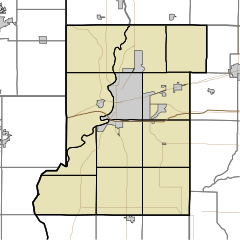
Libertyville is a small place in Indiana, USA. It's known as an unincorporated community. This means it's a group of homes and businesses that don't have their own local government, like a city or town would. Instead, it's governed by the larger Vermillion and Vigo counties.
Libertyville is part of the bigger Terre Haute area. This area is officially called a Metropolitan Statistical Area. It includes the city of Terre Haute and all the nearby communities that are connected to it.
History of Libertyville
Libertyville has a simple but interesting past. One important part of its history involves its post office.
The Post Office Era
A post office was first opened in Libertyville in 1871. This was a very important place for people to send and receive letters and packages. It helped connect the community with the rest of the country. However, the post office eventually closed down in 1904. After that, people in Libertyville likely used post offices in nearby towns.
Geography and Location
Libertyville is located in a specific spot in Indiana. Knowing its geography helps us understand where it is on a map.
Where is Libertyville?
Libertyville is found along a major road called U.S. Highway 150. This highway helps people travel to and from the community. Its exact location can be pinpointed using special coordinates: 39°36′10″N 87°31′07″W / 39.60278°N 87.51861°W. These numbers tell us its precise latitude and longitude on Earth.
 | Bessie Coleman |
 | Spann Watson |
 | Jill E. Brown |
 | Sherman W. White |


