Lime Village, Alaska facts for kids
Quick facts for kids
Lime Village
Hek'dichen Hdakaq'
|
|
|---|---|
 |
|

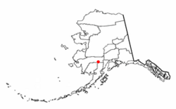
Location of Lime Village, Alaska
|
|
| Country | United States |
| State | Alaska |
| Census Area | Bethel |
| Area | |
| • Total | 78.71 sq mi (203.87 km2) |
| • Land | 76.52 sq mi (198.19 km2) |
| • Water | 2.19 sq mi (5.67 km2) |
| Population
(2020)
|
|
| • Total | 13 |
| • Density | 0.17/sq mi (0.07/km2) |
| Time zone | UTC-9 (Alaska (AKST)) |
| • Summer (DST) | UTC-8 (AKDT) |
| ZIP code |
99557
|
| Area code(s) | 907 |
| FIPS code | 02-44030 |
| GNIS ID | 2418687 |
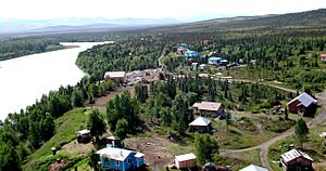
Lime Village (which is called Tanaina: Hek'dichen Hdakaq' by the native people) is a small community in Alaska, United States. It's known as a census-designated place (CDP). This means it's a special area counted by the government for population numbers.
Lime Village is located in the Bethel Census Area, Alaska. In the 2020 census, only 13 people lived there. This was a decrease from 29 people in 2010. The village has also been called Hungry Village in the past.
In 2008, Lime Village became known for having very high gasoline prices. Gas cost more than double the national average at the time. Even though Alaska is a big oil producer, it's hard to transport fuel and other goods to small, spread-out villages like Lime Village. This makes prices much higher.
Where is Lime Village?
Lime Village is located in a remote part of Alaska. Its exact coordinates are 61.341383 degrees North and -155.490944 degrees West.
The United States Census Bureau says that the total area of the community is about 82.5 square miles (213.7 square kilometers). Most of this area, about 80.3 square miles (208 square kilometers), is land. The rest, about 2.2 square miles (5.7 square kilometers), is water.
How Many People Live Here?
| Historical population | |||
|---|---|---|---|
| Census | Pop. | %± | |
| 1940 | 38 | — | |
| 1950 | 29 | −23.7% | |
| 1970 | 25 | — | |
| 1980 | 48 | 92.0% | |
| 1990 | 42 | −12.5% | |
| 2000 | 6 | −85.7% | |
| 2010 | 29 | 383.3% | |
| 2020 | 13 | −55.2% | |
| U.S. Decennial Census | |||
Lime Village first appeared in the U.S. Census in 1940. Back then, it was called "Hungry." It wasn't counted in the 1960 census. The name changed to Lime Village when it reappeared in 1970. In 1980, it officially became a census-designated place (CDP).
The population of Lime Village has changed a lot over the years. In 1980, there were 48 people, but by 2000, only 6 people lived there. The population grew to 29 in 2010, but then dropped to 13 in 2020.
School Life in Lime Village
The Lime Village School used to be run by the Iditarod Area School District. However, it closed in 2007. This happened because the school only had six students, which was less than the ten students required by the state of Alaska.
As of Fall 2008, the school remained closed. When there isn't a local school, it can be harder for families to stay in the village. Many people have moved to bigger towns because of this. However, some families still come back to Lime Village to spend their summers there.
See also
 In Spanish: Lime Village (Alaska) para niños
- Lime Village (Alaska) para niños (This link is to a Spanish version of this article for kids)
 | Mary Eliza Mahoney |
 | Susie King Taylor |
 | Ida Gray |
 | Eliza Ann Grier |


