
List of Indiana state historical markers in Grant County facts for kids

Did you know that Indiana has special markers to remember important places and events? These are called state historical markers. They help us learn about the past!
This page tells you about the official historical markers in Grant County, Indiana. These markers are placed by the Indiana Historical Bureau. Each marker shares a story about something important that happened right here in Grant County. There are 11 historical markers in this county, each with its own unique history!
Contents
Grant County's Historical Markers
Grant County is full of interesting history, and these markers help us explore it. From old battles to important buildings and communities, each marker tells a piece of the story.
Battle of Mississinewa
The Battle of Mississinewa marker was placed in 1947. It remembers a big battle that happened in 1812. This battle involved the U.S. military and Native American people. It was an important event in the early history of Indiana. You can find this marker near Marion.
New Purchase Boundary
In 1966, the New Purchase Boundary (Treaty of St. Mary's) marker was put up. This marker tells about a very important agreement called the Treaty of St. Mary's. This treaty helped set the boundaries for new land in Indiana. It was a big part of how the state grew and changed. The marker is on the lawn of the Grant County Courthouse in Marion.
Miami Indian Cemetery
The Miami Indian Cemetery marker was placed in 1972. This marker points to a special burial ground for the Miami Indian tribe. It reminds us of the rich history and culture of Native Americans in this area. You can find it north of Marion.
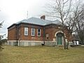
West Ward School
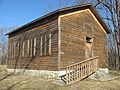
In 1988, the West Ward School marker was put in Gas City. This marker celebrates the history of education and the design of old school buildings. Schools like West Ward were very important for children learning and growing in their communities.
Former Narrow Gauge Railroad
The Former Narrow Gauge Railroad/Railroad Construction marker was placed in 1992. This marker tells about a special kind of train track called a "narrow gauge" railroad. These smaller tracks were important for moving goods and people. They helped businesses and industries grow in Marion.
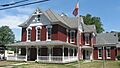
J.W. Patterson House
The J.W. Patterson House marker was placed in 1995. This marker highlights an important building in Fairmount. It reminds us of the interesting architecture and history of homes in the area.
The Village of Trask
Also in 1995, the marker for The Village of Trask was put up. This marker tells the story of a historic village. It helps us remember how towns and neighborhoods developed over time in Grant County.
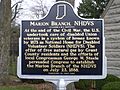
Marion Branch, NHDVS
The Marion Branch, NHDVS marker was placed in 2011. NHDVS stands for the National Home for Disabled Volunteer Soldiers. This marker tells about a special place that cared for soldiers who served our country. It also highlights the important buildings where they lived. This marker is in Marion.
Samuel Plato
In 2014, a marker for Samuel Plato was placed in Marion. Samuel Plato was a very important architect and an African American leader. He designed many buildings and made a big impact on his community.
Weaver Settlement
The Weaver Settlement marker was placed in 2020. This marker celebrates a historic community in Grant County. It helps us remember the people who lived there and their contributions to the area's history.
Allen Temple
The newest marker, Allen Temple, was placed in 2022. This marker is at the Allen Temple AME Church in Marion. It recognizes the church's importance to the African American community and its role in local history and religion.
Images for kids
-
The Battle of Mississinewa marker.
-
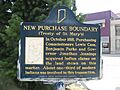
The New Purchase Boundary marker.
-
The Miami Indian Cemetery marker.
-
The West Ward School marker in Gas City.
-
The J.W. Patterson House marker.
-
The Village of Trask marker.
-
The Marion Branch, NHDVS marker.

_historical_marker.jpg)


_PB190312.JPG)
See also
- List of Indiana state historical markers
- National Register of Historic Places listings in Grant County, Indiana
