
List of Indiana state historical markers in Randolph County facts for kids

Have you ever seen a special sign that tells you about something important that happened long ago? These are called historical markers! They help us remember interesting people, places, and events from the past.
This article is about the official state historical markers you can find in Randolph County, Indiana, in the United States. These markers are placed by the Indiana Historical Bureau to teach everyone about Indiana's history. Randolph County has 5 of these cool markers.
Contents
Historical Markers in Randolph County
Historical markers are like outdoor history books. Each one tells a unique story about Randolph County's past. Let's explore what these markers teach us!
Farmland Downtown Historic District

This marker was put up in 2005. It's located at 106 N. Main Street in the town of Farmland, Indiana. This marker celebrates the Farmland Downtown Historic District. A historic district is an area where many old buildings have been kept in their original style. This district shows us what the town looked like long ago. It's important for understanding how towns grew, how buildings were designed, and how people lived and worked in the past. It also highlights the history of farming and transportation in the area.
Lee L. Driver: A Leader in Education
The marker for Lee L. Driver was placed in 2009. You can find it at Driver Middle School, 130 S. County Road 100E, near Winchester, Indiana. Lee L. Driver was a very important person in education. He helped make schools better for students. This marker reminds us of his hard work and how he improved learning for many young people in Indiana. It shows how much one person can do to change education for the better.
Randolph County Quakers
In 2010, a marker was put up for the Randolph County Quakers. It's located at 124 E. Washington St. (SR 32) in Winchester, Indiana. The Quakers are a religious group known for their peaceful beliefs and their work for fairness and equality. Many Quakers settled in Randolph County. This marker helps us remember their history and how they contributed to the community. They often played a big role in helping others and standing up for what was right.
Amanda Way: A Champion for Women
_(page_162_crop).jpg)
The marker for Amanda Way was placed in 2013. You can find it on West Washington St. (SR 32) just west of Meridian St. in Winchester, Indiana. Amanda Way was a brave woman who fought for women's rights, especially for women to have the right to vote. This movement is called women's suffrage. She believed that women should have the same rights as men. This marker honors her important work and her efforts to make society more fair for everyone.
Union Literary Institute: A School for All

The newest marker in Randolph County, placed in 2016, is for the Union Literary Institute. It's located at 8605 East 600 South, near Union City, Indiana. This school was very special because it was one of the first schools in the United States that welcomed students of all races. This means Black and white students learned together at a time when many schools were separated. The Union Literary Institute was a pioneer in equal education and helped many students get an education, no matter their background.
Images for kids
-
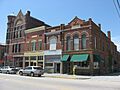
A building in the Farmland Downtown Historic District.
-
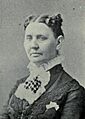
Amanda Way, a leader for women's rights.
-
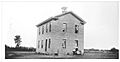
The Union Literary Institute building.
