
List of Pennsylvania state historical markers in Greene County facts for kids

Greene County, Pennsylvania, is a place rich in history! All around the county, you can find special signs called Pennsylvania state historical markers. These markers are like outdoor history books. They tell us about important people, places, and events that happened right there. The Pennsylvania Historical and Museum Commission (PHMC) puts these markers up to help everyone learn about the past. There are 11 of these cool markers in Greene County, each sharing a unique story.
Historical Markers in Greene County
Greene County's history is marked by many interesting stories. Let's explore some of the places and events these markers tell us about.
Forts and Early Settlements
Many markers in Greene County tell us about the early days when settlers built forts for protection.
Fort Jackson
This marker tells us about Fort Jackson. It was an important fort during the American Revolution. It helped protect the early settlers in the area.
- Location: East High Street at Woodland Avenue, Waynesburg
- Dedicated: February 23, 1955
Fort Swan
Another marker points to the site of Fort Swan. This was also a military fort, likely used for defense in the early days.
- Location: PA 88, south of Dry Tavern
Garard's Fort
The marker for Garard's Fort tells us about a fort that played a role in the American Revolution. It also has connections to Native American history in the region.
- Location: Garard's Fort Road (SR 2011), Garard's Fort
- Dedicated: May 23, 1958
Rev. John Corbley
This marker is about Reverend John Corbley. He was an important religious figure in the early days of Greene County. His story is also linked to the Whiskey Rebellion, a time when people protested taxes.
- Location: Garard's Fort Road (SR 2011) & John Corbley Road, Garards Fort
- Dedicated: November 15, 1994
Ryerson's Blockhouse
The marker for Ryerson's Blockhouse tells us about another early defensive structure. Blockhouses were strong buildings used by settlers for protection, often against attacks from Native American groups.
- Location: Wind Ridge Playground, Roy Furman Highway (PA 21), Wind Ridge
- Dedicated: October 17, 1960
Education and Colleges
Greene County has a strong history of education, with several markers dedicated to schools and colleges.
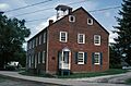
Greene Academy
The Greene Academy marker celebrates an early school in the area. It shows how important education was to the people who settled here.
- Location: North Eighty-Eight Road (PA 88) & West Greene Street, Carmichaels
- Dedicated: May 22, 1953
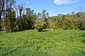
Monongahela College
This marker points to the site of Monongahela College. It was a college that also had ties to religious groups, showing the connection between education and faith in the past.
- Location: Jefferson Road (PA 188) & Pine Street, Jefferson
- Dedicated: May 08, 1960
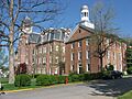
Waynesburg College
There are two markers for Waynesburg College (now Waynesburg University). These markers highlight the long history of this important educational institution in the county. It also had strong ties to religion.
- Location 1: Monument Park, North Morris Street (US 19) at West College Street, Waynesburg
- Location 2: North Richhill Street between West College & West Wayne Streets, Waynesburg
- Dedicated: January 06, 1949 (both markers)
Industry and Innovation
Greene County also has markers that tell us about its industrial past.
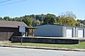
Old Glassworks
The Old Glassworks marker reminds us of a time when glassmaking was an important industry in the area. This shows how people used local resources to create businesses.
- Location: SR 2014, Greensboro
- Dedicated: March 28, 1955
Greene County History
One marker is dedicated to the county itself.
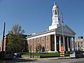
Greene County
This marker celebrates the history of Greene County. It talks about the county's government and how it was formed in the 18th century.
- Location: County Courthouse, High Street, Waynesburg
- Dedicated: May 3, 1982
Images for kids
-

Placeholder image
-
Greene Academy building
-
Greene County Courthouse
-
Site of Monongahela College
-
Site of the Old Glassworks
-
Hanna and Miller Halls at Waynesburg University


See also
- List of Pennsylvania state historical markers
- National Register of Historic Places listings in Greene County, Pennsylvania
