
List of State Register of Heritage Places in the City of Melville facts for kids
The State Register of Heritage Places is a special list kept by the Heritage Council of Western Australia. It helps protect important old buildings and sites in Western Australia. As of 2024, the City of Melville has 172 places listed as heritage sites. Out of these, 24 are considered so important that they are on the State Register of Heritage Places. This means they are officially recognized and protected for future generations to enjoy!
Contents
Discovering Melville's Historic Treasures
The City of Melville is home to many amazing historic places. These sites are listed on the Western Australian State Register of Heritage Places because they tell important stories about the past. Here are some of the cool places you can find in Melville:
Historic Spots in Applecross
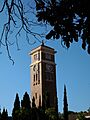
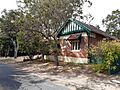
- Applecross District Hall: Built in 1934, this hall is also known as the Tivoli Theatre. It's a single-story community building with a tower, designed in the Art Deco style. It's part of the wider Raffles Hotel area.
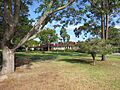
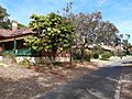
- Applecross Primary School: The original buildings of this school date back to 1913. They show what a one-teacher school room looked like a long time ago. The school also has a Bell Tower from 1929, a Pavilion from 1919, and a School House from 1945, all part of its historic precinct.
- Canning Bridge: This important bridge was built in 1958. It actually has two almost identical timber bridges, one from 1937 and one from 1958. The bridge connects the Cities of Melville and South Perth.
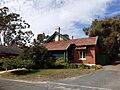
- Grasmere: Also known as Bateman Homestead, this single-story house was built in 1886. It's a great example of the Victorian-Georgian style.
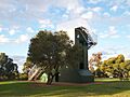
- Heathcote Hospital: Built in 1929, this group of buildings was once called the Point Heathcote Reception Home. They show the design and materials used for public buildings in Western Australia during the late 1920s.
- Raffles Hotel: Originally built in 1896 as the Canning Bridge Hotel, this building is one of the last hotels in Perth that shows the Functionalist style from between the World Wars.
Palmyra's Past
- Millers' Bakehouse Museum: This unique museum in Palmyra was built in 1935. It's a rare example of a small bakery that was also a home.
Wireless Hill Park Wonders
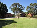
Wireless Hill Park is a very special place in Ardross. It was once a working radio communications station from 1912 to 1967. It's one of only five such stations in Australia! Many parts of the park are heritage-listed:
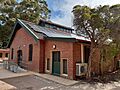
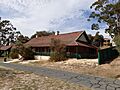
- Caretakers Residence: Built in 1912, this building was also known as the Operators Building.
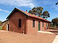
- Engine House: Also from 1912, this building was important for running the station.
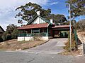
- Museum Group: This area, also called the Telecommunication Station, dates back to 1912.
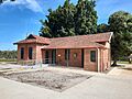
- Store: Built in 1912, this building was used for storage and is also known as the SES Post and Boardroom.
- Village: This area, also from 1912, was part of the original station.
- Wireless Masts: These masts, built in 1912, were crucial for radio communication and are also known as the Lookout Tower.
- Manager's House: The house for the station manager was built in 1912.
- Technicians House: This house for the technicians was also built in 1912.
- Operators Accommodation "The Barracks": Built in 1912, this was where the radio operators lived.
- Senior Telegraphist's Residence: The home for the senior telegraphist was also built in 1912.
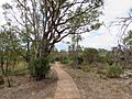
- Heritage Trails: These trails were created in 1969 and are part of the park's history.
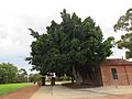
- Moreton Bay Fig Tree: This large, impressive tree is also a listed part of Wireless Hill Park.
These places help us remember and learn about the history of the City of Melville and Western Australia!
Images for kids
-
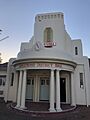
Applecross District Hall, also known as Tivoli Theatre.
-
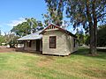
Original buildings of Applecross Primary School.
-
The Bell Tower at Applecross Primary School.
-
The Pavilion at Applecross Primary School.
-
The School House at Applecross Primary School.
-
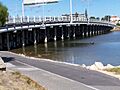
Canning Bridge, connecting Melville and South Perth.
-
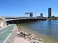
The eastbound section of Canning Bridge.
-
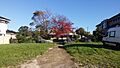
Grasmere, also known as Bateman Homestead.
-
The clocktower at Heathcote Hospital.
-
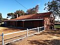
Millers' Bakehouse Museum in Palmyra.
-
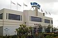
The historic Raffles Hotel.
-
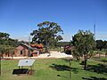
Wireless Hill Park, a former radio station.
-
The Caretakers Residence at Wireless Hill Park.
-
The Engine House at Wireless Hill Park.
-
The Wireless Hill Park Museum Group.
-
The Store building at Wireless Hill Park.
-
The Village area at Wireless Hill Park.
-
One of the Wireless Masts at Wireless Hill Park.
-
The Manager's House at Wireless Hill Park.
-
The Technicians House at Wireless Hill Park.
-
The Operators Accommodation, "The Barracks".
-
The Senior Telegraphist's Residence.
-
One of the Heritage Trails at Wireless Hill Park.
-
The Moreton Bay Fig Tree at Wireless Hill Park.


.jpg)


