
List of State Register of Heritage Places in the Shire of York facts for kids
The State Register of Heritage Places is like a special list of important buildings and sites in Western Australia. It's looked after by the Heritage Council of Western Australia. As of 2023, there are 321 places in the Shire of York that are recognized as important for their history. Out of these, 34 are on the State Register, meaning they are extra special and protected.
Contents
- Discovering York's Historic Places
- Important Buildings in York
- York Courthouse Complex
- York Post Office
- Old York Fire Station
- Eliza's Cottage
- Old York Hospital
- Residency Museum
- York Flour Mill
- Faversham House
- York Primary School
- St Patrick's Catholic Church
- York Town Hall
- Holy Trinity Church
- Marwick's Shed
- York Railway Station
- Monger's Trading Post
- Imperial Hotel
- Gwambygine Homestead
- Other Noteworthy Places
- Important Buildings in York
- Places No Longer on the Register
- Images for kids
Discovering York's Historic Places
The Shire of York is full of amazing old buildings and sites that tell us stories about the past. These places are officially listed on the State Register of Heritage Places. This means they are protected because they are very important to Western Australia's history and culture. Let's explore some of these cool spots!
Important Buildings in York
Many of York's heritage places are buildings that were once used for important community activities. They show us how people lived and worked long ago.
York Courthouse Complex
The York Police Station, Court House & Gaol is a big building that used to be a police station, a courthouse, and even a jail! It's a key part of York's history. You can find it at 124 Avon Terrace.

York Post Office
The York Post Office has been around for a long time. It's where people used to send letters and parcels. It's located at 134 Avon Terrace and still looks much like it did years ago.

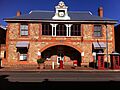
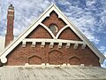
Old York Fire Station
The Old York Fire Station at 151 Avon Terrace once housed the town's fire engines and firefighters. It has also been used as council chambers and a community centre.

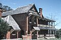
Eliza's Cottage
Eliza's Cottage is a charming old house at 9 Revett Place. It was also known as Lookout for Trains Cottage or Burtons Cottage. It gives us a peek into early home life in York.

Old York Hospital
The Old York Hospital on Brook Street was once the main hospital for the area. It was also known as Avonmoore. It played a big role in caring for the community's health.

Residency Museum
The Residency Museum at 5 Brook Street used to be the Residency, and later, nursing quarters. Today, it's a museum where you can learn about York's past.
.JPG)
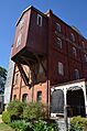
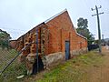
York Flour Mill
The York Flour Mill at 10 Henrietta Street was a busy place where grain was turned into flour. It was also known as the Empire Roller Flour Mill. It shows how important farming was to the region.

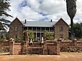
Faversham House
Faversham House is a beautiful old building at 24 Grey Street. It's a great example of the grand homes built in York's early days.

York Primary School
The York Primary School on Howick Street has educated many generations of York's children. It was also known as York Mixed, York Junior High School, and York Boys School.

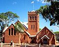
St Patrick's Catholic Church
St Patrick's Catholic Church, Presbytery & Hall at 22 South Street is an important religious site. It includes the church, the presbytery (where the priest lives), and a hall.

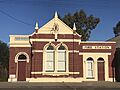
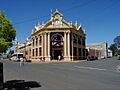
York Town Hall
The York Town Hall at 79-81 Avon Terrace is a very grand building. It has been a central place for community events and meetings for many years. It also includes the York Roll of Honour.

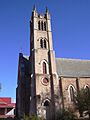
Holy Trinity Church
Holy Trinity Church at the corner of Newcastle & Pool Streets is another significant church in York. It includes the church and its hall.
.jpg)
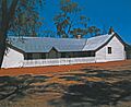
Marwick's Shed
Marwick's Shed at 19-21 Newcastle Street, also known as Marwicks Barn, is a historic shed. It reminds us of the agricultural past of the area.

York Railway Station
The York Railway Station (former) at 13 Railway Street was once a busy hub for trains and passengers. It played a big part in connecting York to other towns.

Monger's Trading Post
Monger's Trading Post (former) at 165 Avon Terrace was an important trading spot. It was also known as the Sandalwood Yard.

Imperial Hotel
The Imperial Hotel at 83 Avon Terrace is a historic hotel. It has welcomed visitors and locals for many years.

Gwambygine Homestead
Gwambygine Farm and Pool is a historic farm located at the intersection of Ovens Road & Great Southern Highway. It's a great example of early homesteads in the region.

Other Noteworthy Places
The State Register also includes other interesting sites that are not buildings.
St Andrew's Anglican Church & Cemetery
St Andrew's Anglican Church & Cemetery in Greenhills is a peaceful and historic site. It includes both a church and a cemetery.
York-Beverley Racecourse
The York-Beverley Racecourse on North Road is a historic place for horse racing. It includes the grandstand, where spectators would watch the races.
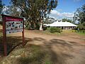
St Ronan's Well, York
St Ronan's Well, York, on the Great Southern Highway, is a natural spring. It was an important water source in the past and is now a conservation area.
Places No Longer on the Register
Sometimes, a place might be removed from the State Register of Heritage Places. This can happen for different reasons.
Former War Memorial, York
The War Memorial, York, on Railway Street, was once on the register. It was a monument and park, also known as the Fallen Soldier's Memorial. It was removed from the register on 1 July 2021.
Images for kids
-
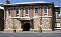
The historic York Courthouse.
-
The old York Post Office building.
-
The former York Fire Station.
-
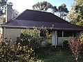
Eliza's Cottage, a historic home.
-
The historic Old York Hospital.
-
The Residency Museum in York.
-
The historic York Flour Mill.
-
Faversham House, a grand old building.
-
The former York Primary School building.
-
St Patrick's Catholic Church in York.
-
The impressive York Town Hall.
-
Holy Trinity Church in York.
-
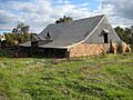
Marwick's Shed, a historic barn.
-
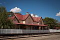
The former York Railway Station.
-
Monger's Trading Post in York.
-
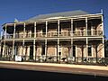
The historic Imperial Hotel.
-
Gwambygine Homestead.
