
List of traffic circles in Washington, D.C. facts for kids

Washington, D.C., has a unique way its roads are laid out. Imagine a giant checkerboard of streets! Most streets running north-south have numbers, like 1st Street or 14th Street. Streets running east-west have letters, like A Street or M Street.
But that's not all! Avenues named after each of the 50 U.S. states cut across this grid diagonally. Where these state avenues meet, you often find special round areas called traffic circles, or roundabouts. These circles help traffic flow smoothly. Many of them are named after important people, like generals and admirals from the American Civil War. Some neighborhoods in D.C. even get their names from these nearby circles. There are about 36 traffic circles in Washington, D.C.
Contents
Exploring Washington D.C.'s Traffic Circles
Traffic circles are a big part of how people get around in D.C. They help cars move from one street to another without needing a traffic light at every intersection. This can make driving a bit faster and smoother.
Famous Circles in Northwest D.C.
The Northwest part of D.C. has many well-known traffic circles. Each one has its own story or special features.
Dupont Circle: A Busy Hub
Dupont Circle is one of the most famous. It's where several important avenues meet, like Connecticut, Massachusetts, and New Hampshire Avenues. It's a very busy spot, and it even has an underpass for Connecticut Avenue to help traffic flow even better. Many people visit Dupont Circle to relax, meet friends, or enjoy the fountain in its center.
Logan Circle: A Historic Spot
Logan Circle is another important one. It's named after John A. Logan, a general from the Civil War. This circle is known for its beautiful historic homes around it. It's a popular place for people to live and visit.
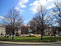
Thomas Circle: A Major Intersection
Thomas Circle is a large circle where Massachusetts and Vermont Avenues cross. Like Dupont Circle, it has an underpass to help traffic move through quickly. It's a key point for drivers heading into or out of downtown D.C.
Other Notable Circles in Northwest
- Scott Circle also has an underpass for 16th Street, a major road.
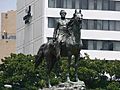
- Sheridan Circle is located on Massachusetts Avenue, often called "Embassy Row" because many country embassies are nearby.
- Washington Circle is near George Washington University and is a busy spot for students and city residents.
- Observatory Circle is unique because it doesn't form a full circle. It's next to the United States Naval Observatory, which is where the Vice President of the United States lives at Number One Observatory Circle.
Circles in Northeast D.C.
The Northeast section of D.C. also has some interesting circles.
Columbus Circle: Gateway to the City
Columbus Circle is a very important circle because it's right in front of Union Station. Union Station is a huge train station where many people arrive in D.C. The circle is sometimes called "Columbus Plaza" and used to be known as "Union Station Plaza." Because of the station, it's more like a semicircle than a full circle.
Dave Thomas Circle: A Modern Addition
Dave Thomas Circle is a newer, triangular area that acts like a traffic circle. It helps manage traffic where Florida Avenue, New York Avenue, and First Street Northeast meet. Even though it wasn't part of the original city plan, it works like the older circles to keep cars moving.
Truxton Circle: A Circle That Disappeared
Interestingly, Truxton Circle no longer exists as a physical circle. It was once an intersection of several streets, but it was removed to improve traffic flow. However, the name "Truxton Circle" still lives on as the name of a neighborhood in that area.
Circles in Southeast and Southwest D.C.
The southern parts of D.C. also have their share of circles.
Barney Circle: Near a Famous Stadium
Barney Circle is in Southeast D.C. It's near where the RFK Stadium used to be, and it has an underpass that helped with stadium parking.
Lincoln Memorial Circle: Around a Landmark
Lincoln Memorial Circle is a very special circle. It surrounds the famous Lincoln Memorial in Southwest D.C. This circle helps guide visitors to one of America's most important monuments.
Images for kids
-
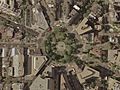
Aerial photograph of Dupont Circle
-
Thomas Circle
-
Sheridan Circle
-
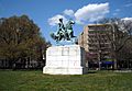
Washington Circle


See also
 In Spanish: Anexo:Rotondas en Washington D. C. para niños
- Geography of Washington, D.C.
- Streets and highways of Washington, D.C.
- Transportation in Washington, D.C.
