
Barney Circle facts for kids
Quick facts for kids
Barney Circle
|
|
|---|---|
|
Neighborhood
|
|

800 block of Kentucky Avenue SE in the
Barney Circle neighborhood |
|

Map of Washington, D.C., with the Barney Circle neighborhood highlighted in red
|
|
| Country | United States |
| Territory | Washington, D.C. |
| Constructed | c. 1917 |
| Named for | Commodore Joshua Barney |
Barney Circle is a small neighborhood in Washington, D.C.. It's located in the southeast part of the city. You can find it between the Anacostia River and Capitol Hill. People who live here love their community. They are active and enjoy walking around. The area also has a historic feel.
The neighborhood gets its name from a former traffic circle. This circle was on Pennsylvania Avenue SE. It was just before the road crosses the John Philip Sousa Bridge. The traffic circle was named after Joshua Barney. He was a brave naval officer. Commodore Barney led the Chesapeake Bay Flotilla in the War of 1812.
Contents
Exploring Barney Circle
The Barney Circle neighborhood covers a specific area. It's bordered by Pennsylvania Avenue SE and Potomac Avenue SE. The other sides are 15th Street SE and 17th Street SE. However, some people living nearby also feel they are part of Barney Circle. This includes residents from Lincoln Park and Capitol Hill East. The neighborhood's exact edges can be a bit blurry. It might stretch north to East Capitol Street. It could go south to the Southeast Boulevard. It might even reach east to the D.C. Jail.
A Look Back in Time
The area around Barney Circle started developing slowly. The Congressional Cemetery was created in 1807. Another cemetery, Eastern Methodist, was there from 1824 to 1892. Even though it was near Eastern Market and the Washington Navy Yard, the area stayed mostly empty. Streets were not paved for a long time. A bridge connecting the neighborhood to areas east of the Anacostia River wasn't built until 1890.
Things changed around 1902. A man named Arthur E. Randle got permission to build streetcar tracks. These tracks crossed the new bridge. The first houses in the main part of the neighborhood appeared in 1905. By 1908, streetcars ran from the Capitol. They went along Pennsylvania Avenue SE to Barney Circle. They even crossed the bridge to Randle Highlands.
In 1911, the Congress officially named the traffic circle "Commodore Barney Circle." This was after a local builder shared information about Commodore Barney. The neighborhood grew quickly between 1919 and 1924. More than 70% of its buildings were built then. Many people who lived here worked at the Washington Navy Yard. Their homes were simple but comfortable. Most were two-story brick rowhouses. They usually had two or three bedrooms and small yards.
These homes were special for their time. They were wider and shallower than older homes on Capitol Hill. This design allowed more sunlight into each room. They were called "daylight rowhouses." Homes in Barney Circle are usually set back from the street. They have a small front yard and an open porch. Many have mansard roofs with dormers. These provide extra space on the third floor.
Even today, the neighborhood looks much like it did long ago. Most homeowners have kept their homes' historic appearance.
Schools in the Neighborhood
The DCPS system has schools that serve Barney Circle. These include Eastern High School. There's also the Capitol Hill Cluster School. This cluster school has three campuses. They are Stuart-Hobson Middle School, Watkins Elementary School, and Peabody Elementary School.
Famous people have even visited these schools. President Barack Obama visited Stuart-Hobson in 2011. First Lady Michelle Obama surprised students at Watkins in 2016. She was there to promote gardening.
There is also a charter school in Barney Circle. Friendship Public Charter School serves students from pre-kindergarten through eighth grade.
How the Neighborhood is Governed
Barney Circle is part of Ward 6 in Washington, D.C. Charles Allen has been the representative for this area. He serves on the Council of the District of Columbia.
The main part of the community is in Advisory Neighborhood Commission (ANC) 6B. ANCs are local groups that advise the city government. Barney Circle is mostly in ANC 6B09. It might also extend into other ANC areas nearby.
Community Life and Fun
The Congressional Cemetery is a special place here. It was created in 1807. Many famous people are buried there. These include Elbridge Gerry, who signed the Declaration of Independence. Mathew Brady, a Civil War photographer, is also buried there. So is John Philip Sousa, the "March King." Even a former FBI Director rests there.
The cemetery has become a lively spot. It has a K9 program where dogs can roam freely. They also have "Rest in Bees" honey and music concerts. You can even watch movies or have weddings there!
The building of Nationals Park in Navy Yard helped the neighborhood grow. It's about a 35-minute walk from Barney Circle. New places like Trusty's Full-Serve bar opened. Trusty's has been a local tavern since 2005. Fans of the Washington Nationals and DC United often gather there. Wisdom, a gin parlor, opened in 2008. It's known for its fancy drinks.
A new pedestrian bridge also connects the neighborhood to The Wharf. This is thanks to the Anacostia Riverwalk Trail.
Barney Circle has three other green spaces. Residents walk their dogs there. They also do "guerrilla gardening" to make the area beautiful. These spots are Dennis Dolinger Memorial Park, Commodore Barney Circle itself, and the Pennsylvania Avenue SE median.
A large new "culinary clubhouse" called "The Roost" is planned. It will have many different food and drink options. This includes a sundae shop, a taco stand, and various bars.
The Hill Rag is a local newspaper. It has reported on Barney Circle since 1976.
The Seafarers Yacht Club of Washington, DC is also nearby. It was started in 1944. It's the oldest African American boat club on the East Coast.
Getting Around
Barney Circle is easy to reach. You can use the metro, express buses, or highways. There are also Capital Bikeshare docks. The neighborhood is served by the Potomac Avenue station and Stadium–Armory station metro stops. The 36 Pennsylvania Avenue bus line also runs through the area.
The John Philip Sousa Bridge was finished in 1942. It's named after the famous composer. He was from D.C. and died in 1933.
The Traffic Circle's Story
Barney Circle was part of the original plan for Washington, D.C. It was first meant to be a square. But by 1903, it was built as a traffic circle. It was called "Pennsylvania Avenue Circle." In 1911, President William Howard Taft officially changed its name to "Commodore Barney Circle." This honored Commodore Joshua Barney.
Over the years, the traffic circle changed. In 1939, a new part of the John Philip Sousa Bridge was built. This changed Barney Circle's shape. A streetcar turnaround and bus lane were added. A bus and streetcar terminal also opened in 1941. It closed in 1960.
Big Road Plans and Community Action
In the 1950s, city planners wanted to build a huge highway system. This was called the "Inner Loop Expressway." It would have changed much of D.C. As part of this plan, Barney Circle was rebuilt again in 1971. It got freeway ramps connecting to other roads. But many people protested these plans. After two decades of protests, most of the highway project was canceled in 1977.
Because the Inner Loop wasn't finished, the roads around Barney Circle became confusing. Traffic often got stuck. For example, a highway (Interstate 695) led to a one-lane ramp onto the bridge. This caused long traffic jams.
In 1975, planners suggested a new highway. It was called the "Barney Circle Freeway." It aimed to fix the traffic problems. This freeway would have gone along the Anacostia River. It would have connected to Robert F. Kennedy Memorial Stadium. A new bridge was also planned. This project was ready to start in 1981. But people living in Capitol Hill worried about more traffic. Environmental groups also protested. The city agreed to make the freeway smaller.
But the protests and legal challenges continued. By 1992, the freeway's cost had grown a lot. Still, D.C. Mayor Sharon Pratt Kelly approved construction in 1993. However, many groups sued to stop it. These included the Sierra Club and local neighborhood groups. They wanted the freeway to be even smaller. They also wanted changes to local streets.
In 1994, the Federal Highway Administration said the project was okay. But the D.C. City Council had the final say. In December 1994, the City Council listened to the neighborhood. They voted to reject the project. This was a big win for the community!
Making Barney Circle Better
After the highway plans were canceled, traffic was still a problem. Drivers often had to wait at traffic lights. They also had to make dangerous turns to get to other highways. This caused huge traffic jams during busy hours.
In 2009, the District of Columbia Department of Transportation (DDOT) started a big project. They began replacing the 11th Street Bridges. They closed parts of Interstate 695 in 2012 and 2013. This section of the highway was then removed. About five blocks of the highway became regular city streets. New ramps were built to separate local traffic from through-traffic. This made it much easier to get around.
These changes greatly reduced traffic on the Sousa Bridge. DDOT also improved the ramp from Pennsylvania Avenue SE. This made it much safer.
The old Interstate 695 highway is now being turned into a "Southeast Boulevard." This new road will be raised to be level with other streets. It will be a four-lane road with a landscaped middle section. It will also have a walking trail. This boulevard will connect Barney Circle to 11th Street SE.
In 2013, DDOT shared plans to redesign Barney Circle. They want to make it easier to reach local streets. They also want to add paths for walkers and bikers. These paths would connect to the Anacostia River waterfront. DDOT is also thinking about making Barney Circle a "transportation hub." This means it would be a central place for different types of travel. Construction on these plans might start in the future.
 |
Kingman Park | |
||
| Capitol Hill | Congressional Cemetery | |||
| Anacostia River |
Images for kids
-
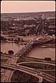
The John Philip Sousa Bridge in 1973, with Barney Circle on the far side.
-
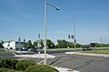
Looking north-northeast at Barney Circle from K Street SE.
-
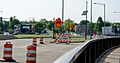
The now-unused off-ramp to Interstate 695 near Barney Circle in May 2014.
-
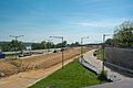
Looking southwest from Barney Circle at the old Interstate 695 being removed.


