List of creeks of the Bahamas facts for kids
Welcome to a list of creeks in The Bahamas! We'll explore these cool waterways on different islands. Did you know The Bahamas only has one true river? It's called the Goose River and it's on Central Andros Island. But there are also many 'tidal creeks'. These look a lot like rivers, but their water levels change with the ocean tides.
In March 2018, something amazing happened on Eleuthera Island! Big waves near the Glass Window Bridge flowed right across the island. This water even washed out a road called Queens Highway, and for a short time, people called it a 'new river'!
Contents
Andros Island: Home to the Only River
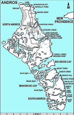
Andros Island is special because it has The Bahamas' only true river, the Goose River. It also has many interesting creeks.
| Name | Location |
|---|---|
| Cargill Creek | Central Andros, Cargill Cay |
| Deep Creek | North Andros, Deep Creek |
| Deep Creek | South Andros, 23°59′30″N 77°31′49″W / 23.99164°N 77.53028°W |
| Fresh Creek | North Andros, Fresh Creek |
| Goose River | Central Andros |
| Grassy Creek | South Andros, 23°47′31″N 77°32′03″W / 23.79198°N 77.53418°W |
| Hawk Creek | North Andros |
| Lisbon Creek | Mangrove Cay |
| Little Grassy Creek | South Andros |
| Loggerhead Creek | North Andros |
| Mount Creek | North Andros |
| Pelican Creek | North Andros |
| River Lees | North Andros, Fresh Creek |
| Sandy Creek | North Andros |
| Sapodilla Creek | North Andros |
| Simon Creek | North Andros |
| Somerset Creek | North Andros |
| Stafford Creek | North Andros, Stafford Creek, 24°53′40″N 77°56′13″W / 24.89435°N 77.93692°W |
| Staniard Creek | North Andros |
| Timber Creek | North Andros |
| Wide Opening | Fresh Creek, 24°25′00″N 78°11′00″W / 24.41667°N 78.18333°W |
Eleuthera Island: Starve Creek
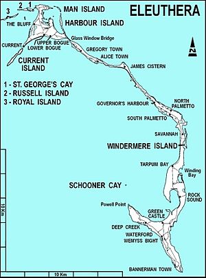
Eleuthera Island has one main creek. There's also a town in South Eleuthera named Deep Creek, even though the creek itself isn't there.
- Starve Creek, 24°49′N 76°11′W / 24.817°N 76.183°W
Berry Islands: Stafford Creek
The Berry Islands are home to one known creek.
- Stafford Creek, Berry Islands, 25°54′00″N 77°56′00″W / 25.9°N 77.93333°W
Abaco Islands: Many Tidal Creeks
The Abaco Islands have many tidal creeks. Remember, tidal creeks are waterways where the water level changes with the ocean's tides.
| Name | Location | Coordinates |
|---|---|---|
| Big Lake Creek | Hope Town | 26°40′24″N 77°17′58″W / 26.67326°N 77.29938°W |
| Big Mangrove Creek (marine channel) | North Abaco | 26°48′58″N 77°56′40″W / 26.816°N 77.94458°W |
| Bill Bride Creek | North Abaco | 26°49′35″N 77°54′55″W / 26.8264°N 77.91524°W |
| Broad Creek | Central Abaco | 26°29′10″N 77°02′29″W / 26.48601°N 77.04139°W |
| Calcutta Creek | Central Abaco | 26°31′52″N 77°02′57″W / 26.53104°N 77.04929°W |
| Coconut Creek | Hope Town | 26°38′41″N 77°04′31″W / 26.64461°N 77.0754°W |
| Deals Creek | Central Abaco | 26°35′41″N 77°17′44″W / 26.59465°N 77.29555°W |
| Don't Bluff Creek | Central Abaco | 26°34′39″N 77°14′47″W / 26.57756°N 77.2465°W |
| Far Creek | Central Abaco | 26°32′33″N 77°04′03″W / 26.54242°N 77.06741°W |
| First Creek | Central Abaco | 26°38′14″N 77°20′26″W / 26.63717°N 77.34051°W |
| Fish Creek | Central Abaco | 26°39′39″N 77°19′17″W / 26.66073°N 77.3213°W |
| Hills Creek | Central Abaco | 26°38′13″N 77°16′45″W / 26.63691°N 77.27926°W |
| Hills Creek | Central Abaco | 26°37′57″N 77°16′19″W / 26.63256°N 77.272°W |
| Israel Creek | Central Abaco | 26°34′16″N 77°10′44″W / 26.57098°N 77.17886°W |
| Joe's Creek | Central Abaco | 26°37′36″N 77°15′51″W / 26.62675°N 77.26426°W |
| Little Creek | Central Abaco | 26°38′03″N 77°26′00″W / 26.63421°N 77.43345°W |
| Loggerhead Creek | Central Abaco | 25°06′00″N 78°11′00″W / 25.1°N 78.18333°W |
| Mangrove Creek | Central Abaco | 26°41′09″N 77°24′08″W / 26.68596°N 77.40234°W |
| Mangrove Creek | North Abaco | 26°41′09″N 77°24′08″W / 26.68596°N 77.40234°W |
| Mitchell Creek | Central Abaco | 26°40′24″N 77°20′43″W / 26.67344°N 77.34536°W |
| Nigh Creek | Central Abaco | 26°32′32″N 77°03′44″W / 26.54215°N 77.06226°W |
| Nimble Creek | Central Abaco | 26°39′01″N 77°17′34″W / 26.65039°N 77.29272°W |
| Okra Creek | Central Abaco | 26°36′06″N 77°13′22″W / 26.60169°N 77.22279°W |
| Sand Banks Harbour | Hope Town | 26°40′45″N 77°18′29″W / 26.67908°N 77.30798°W |
| Second Creek | Central Abaco | 26°38′27″N 77°20′10″W / 26.64096°N 77.33598°W |
| Senacord Creek | Central Abaco | 26°31′06″N 77°02′54″W / 26.51847°N 77.0484°W |
| Treasure Cay Creek | Cape Town | 26°40′16″N 77°16′45″W / 26.67106°N 77.27929°W |
| Turtle Creek | Central Abaco | 26°30′42″N 77°02′52″W / 26.51175°N 77.04788°W |
| Wallace Creek | Central Abaco | 26°35′58″N 77°12′49″W / 26.59952°N 77.21358°W |
| Wills Cay Creek | Central Abaco | 26°34′59″N 77°13′37″W / 26.58304°N 77.22684°W |
| Will's Creek | Central Abaco | 24°21′52″N 78°06′05″W / 24.36437°N 78.1015°W |
Mangrove Cay: Miller Creek
Mangrove Cay has its own special creek.
- Miller Creek, 24°01′15″N 77°50′18″W / 24.02071°N 77.83847°W
Grand Bahama: Creeks and Channels
Grand Bahama Island features both a tidal creek and a channel.
- Thrift Harbor Creek, tidal creek, East Grand Bahama, 26°33′N 77°51′W / 26.55°N 77.85°W
- Hawksbill Creek, channel, West Grand Bahama, 26°32′00″N 78°43′00″W / 26.53333°N 78.71667°W
See also
 | Sharif Bey |
 | Hale Woodruff |
 | Richmond Barthé |
 | Purvis Young |


