List of districts in Mizoram facts for kids

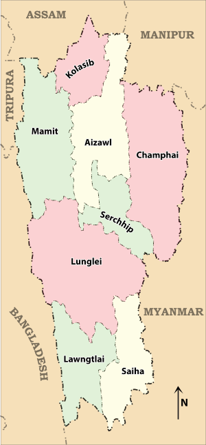
The Indian state of Mizoram is located in the northeastern part of the country. Like many states, Mizoram is divided into smaller areas called districts. These districts help to manage the state better and bring government services closer to the people. Currently, Mizoram has 8 districts.
Contents
How Mizoram is Governed
Each district in Mizoram has its own team of officials who help run things smoothly. This system makes sure that laws are followed, and public services are available to everyone.
Who Manages a District?
The main person in charge of a district is called the Deputy Commissioner. Think of them as the district's chief executive. They have a very important job because they actually hold three different roles at once:
- As the Deputy Commissioner, they are the top boss of the district's daily operations.
- As the District Magistrate, they are responsible for keeping law and order. This means they make sure rules are followed and people are safe.
- As the District Collector, they are the main officer for collecting money (revenue) for the government from the district.
Keeping Law and Order
Besides the Deputy Commissioner, each district also has a Superintendent of Police (SP). This person is the head of the police force in that district. Their job is to make sure the police do their work well and keep the peace.
Districts are also divided into smaller parts to make management easier. These smaller parts are called subdivisions, and they are further divided into areas known as tehsils and blocks.
Mizoram's Districts List
Here is a list of the 8 districts in Mizoram, along with some interesting facts about them:
| Code | District | Headquarters | Established | Subdivisions | Area | Population As of 2001[update] | Population Density |
|---|---|---|---|---|---|---|---|
| AI | Aizawl | Aizawl | 3,577 km2 (1,381 sq mi) | 339,812 | 95/km2 (250/sq mi) | ||
| KO | Kolasib | Kolasib | 1998 | 1,386 km2 (535 sq mi) | 60,977 | 44/km2 (110/sq mi) | |
| LA | Lawngtlai | Lawngtlai | 2,519 km2 (973 sq mi) | 73,050 | 29/km2 (75/sq mi) | ||
| LU | Lunglei | Lunglei | 4,572 km2 (1,765 sq mi) | 137,155 | 30/km2 (78/sq mi) | ||
| MA | Mamit | Mamit | 1998 | 2,967 km2 (1,146 sq mi) | 62,313 | 21/km2 (54/sq mi) | |
| SI | Siaha | Saiha | 1998 | 1,414 km2 (546 sq mi) | 60,823 | 43/km2 (110/sq mi) | |
| SE | Serchhip | Serchhip | 1998 | 1,424 km2 (550 sq mi) | 55,539 | 39/km2 (100/sq mi) | |
| CH | Champhai | Champhai | 1998 | 3,168 km2 (1,223 sq mi) | 101,389 | 32/km2 (83/sq mi) | |
| Total | 21,087 km2 (8,142 sq mi) | 888,573 | 42/km2 (110/sq mi) |
Future Districts in Mizoram
Sometimes, new districts are created to make it easier to manage different areas. Here are some proposed new districts that might be formed in Mizoram:
- Khawzawl, which would be created from parts of Champhai district.
- Saitual, which would be created from parts of Aizawl district.
- Sinlung Hills, which would include areas from both Champhai district and Aizawl district. This area is planned to be part of the Sinlung Hills Autonomous District Council.
- Hnahthial, which would be created from parts of Lunglei district.
- Chawngte, which would be created from parts of Lawngtlai district. This area is part of the Chakma Autonomous District Council.
- Sangau, which would be created from parts of Saiha district. This area is part of the Lai Autonomous District Council.
 | Stephanie Wilson |
 | Charles Bolden |
 | Ronald McNair |
 | Frederick D. Gregory |

