List of districts in Odisha facts for kids
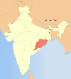
Odisha is a state located on the eastern coast of India. To help manage everything smoothly, Odisha is divided into 30 smaller areas called districts. Think of them like different neighborhoods or regions within the state, each with its own special features and people.
Understanding Odisha's Districts
Odisha is a big state, so it's split into 30 districts to make it easier to manage. Each district has its own leader and team to make sure things run well for everyone living there.
How Districts are Managed
Each district in Odisha has a main leader called a District Collector (DC). This person is like the manager of the whole district. Their job is super important!
The District Collector has two main roles. First, they are like a judge, making sure that rules are followed and keeping things peaceful. This is called maintaining law and order. Second, they help collect money for the government, which is used to build schools, roads, and hospitals.
Most District Collectors are highly skilled officers from the Indian Administrative Service (IAS). Sometimes, officers from Odisha's own Civil Service also get this important job.
The District Collector works with many other officials. These officials help provide different services to the people, like healthcare, education, and public transport.
There's also a special police officer called the Superintendent of Police. This officer is part of the Indian Police Service and is in charge of all police matters in the district. Their main goal is to keep everyone safe and make sure laws are followed.
Meet the Districts of Odisha
Odisha has 30 districts, and each one is unique! They vary in size and how many people live there. The table below shows you some interesting facts about each district, like its population (how many people live there) and its area (how big it is). The numbers are based on the 2001 and 2011 population counts.
| Sr No | Code | District | Headquarters | Population (2001 Census) |
Population (2011 Census) |
Area (km²) | Density in 2011 (/km²) |
|---|---|---|---|---|---|---|---|
| 1 | AN | Angul | Angul | 1,140,003 | 1,273,821 | 6,376 | 199.8 |
| 2 | BD | Boudh (Baudh) | Boudh | 373,372 | 441,162 | 3,098 | 142.4 |
| 3 | BL | Balangir | Balangir | 1,337,194 | 1,648,997 | 6,575 | 250.8 |
| 4 | BR | Bargarh (Baragarh) | Bargarh | 1,346,336 | 1,481,255 | 5,837 | 253.8 |
| 5 | BW | Balasore (Baleswar) | Balasore | 2,024,508 | 2,320,529 | 3,806 | 609.7 |
| 6 | BH | Bhadrak | Bhadrak | 1,506,522 | 2,505 | 601 | |
| 7 | CU | Cuttack | Cuttack | 2,341,094 | 2,624,470 | 3,932 | 667.5 |
| 8 | DE | Debagarh (Deogarh) | Debagarh | 274,108 | 312,520 | 2,940 | 106.3 |
| 9 | DH | Dhenkanal | Dhenkanal | 1,066,878 | 1,192,811 | 4,452 | 267.9 |
| 10 | GN | Ganjam | Chhatrapur | 3,130,635 | 3,529,031 | 8,206 | 430.1 |
| 11 | GP | Gajapati | Paralakhemundi | 518,837 | 577,817 | 4,325 | 133.6 |
| 12 | JH | Jharsuguda | Jharsuguda | 509,716 | 579,505 | 2,114 | 274.1 |
| 13 | JP | Jajpur | Jajpur | 1,624,341 | 1,827,192 | 2,899 | 595.8 |
| 14 | JS | Jagatsinghapur | Jagatsinghapur | 1,057,629 | 1,136,971 | 1,668 | 681.6 |
| 15 | KH | Khordha | Khordha | 1,877,395 | 2,251,673 | 2,813 | 800.5 |
| 16 | KJ | Kendujhar (Keonjhar) | Kendujhar | 1,561,990 | 1,801,733 | 8,303 | 217.0 |
| 17 | KL | Kalahandi | Bhawanipatna | 1,335,494 | 1,576,869 | 7,920 | 199.1 |
| 18 | KN | Kandhamal | Phulbani | 648,201 | 733,110 | 8,021 | 91.4 |
| 19 | KO | Koraput | Koraput | 1,180,637 | 1,379,647 | 8,807 | 156.7 |
| 20 | KP | Kendrapara | Kendrapara | 1,302,005 | 1,440,361 | 2,644 | 544.8 |
| 21 | ML | Malkangiri | Malkangiri | 504,198 | 613,192 | 5,791 | 105.9 |
| 22 | MY | Mayurbhanj | Baripada | 2,223,456 | 2,519,738 | 10,418 | 241.9 |
| 23 | NB | Nabarangpur | Nabarangapur | 1,025,766 | 1,220,946 | 5,291 | 230.8 |
| 24 | NU | Nuapada | Nuapada | 530,690 | 610,382 | 3,852 | 158.5 |
| 25 | NY | Nayagarh | Nayagarh | 864,516 | 962,789 | 3,890 | 247.5 |
| 26 | PU | Puri | Puri | 1,502,682 | 1,698,730 | 3,479 | 488.3 |
| 27 | RA | Rayagada | Rayagada | 831,109 | 967,911 | 7,073 | 136.8 |
| 28 | SA | Sambalpur | Sambalpur | 935,613 | 1,041,099 | 6,624 | 157.2 |
| 29 | SA | Subarnapur (Sonepur) | Subarnapur | 541,835 | 610,183 | 2,337 | 261.1 |
| 30 | SN | Sundergarh | Sundergarh | 1,830,673 | 9,712 | 188 | |
| Total State | 36,804,660 | 41,974,218 | 155,707 | 269.6 |
 | Roy Wilkins |
 | John Lewis |
 | Linda Carol Brown |


