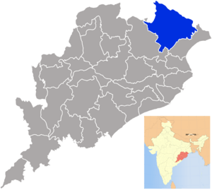
Mayurbhanj district facts for kids
Quick facts for kids
Mayurbhanj district
ମୟୂରଭଞ୍ଜ
|
|
|---|---|
|
District
|
|

Location in Odisha, India
|
|
| Country | |
| State | Odisha |
| Headquarters | Baripada |
| Area | |
| • Total | 10,418 km2 (4,022 sq mi) |
| Elevation | 559.31 m (1,835.01 ft) |
| Population | |
| • Total | 2,519,738 |
| • Density | 241.864/km2 (626.425/sq mi) |
| Languages | |
| • Official | Odia, English |
| Time zone | UTC+5:30 (IST) |
| PIN |
757 xxx
|
| Vehicle registration | OD-11 |
| Sex ratio | 1,005 ♂/♀ |
| Literacy | 65.98% |
| Lok Sabha constituency | Mayurbhanj |
| Vidhan Sabha constituency | 9
026-Jashipur(ST)
027-Saraskana(ST) 028-Rairangpur(ST) 029-Bangiriposi(ST) 030-Karanjia(ST) 031-Udala(ST) 032-Badasahi(SC) 033-Baripada(ST) 034-Morada |
| Precipitation | 1,648.2 millimetres (64.89 in) |
Mayurbhanj district is a special place in Odisha, India. It is one of the 30 districts that make up the state. The main city and headquarters of this district is Baripada.
Mayurbhanj is quite large, covering an area of about 10,418 square kilometers. Imagine a space bigger than many cities! In 2011, over 2.5 million people lived here. That's a lot of people calling Mayurbhanj home!
What is Mayurbhanj District?
Mayurbhanj is a district, which is like a big region or area within a state. It has its own local government and is managed by special officers. These officers help make sure everything runs smoothly for the people living there.
Where is Mayurbhanj Located?
This district is located in the eastern part of India, within the state of Odisha. It's known for its beautiful natural areas and rich history. The coordinates for Mayurbhanj are 21.933° North latitude and 86.733° East longitude.
How Big is Mayurbhanj?
Mayurbhanj district covers a large area of 10,418 square kilometers. To give you an idea, that's about 4,022 square miles. It's a big space with different types of land, from plains to hills.
How Many People Live Here?
According to a count in 2011, there were 2,519,738 people living in Mayurbhanj. This makes it one of the more populated districts in Odisha. The people living here speak mostly Odia, which is the official language of Odisha. English is also used.
What is the Sex Ratio?
The sex ratio tells us how many females there are for every 1,000 males. In Mayurbhanj, for every 1,000 males, there are 1,005 females. This means there are slightly more females than males in the district.
How Many People Can Read and Write?
Literacy is about how many people can read and write. In Mayurbhanj, about 65.98% of the people can read and write. This shows that education is important in the district.
Who Manages Mayurbhanj?
The district has important leaders who help run things. They work to make sure the district is a good place to live for everyone.
Key Leaders in the District
- District Collector & District Magistrate: This person is like the main boss of the district. Their name is Shri Vineet Bhardwaj. They are part of the IAS, which is a group of highly trained government officers.
- Divisional Forest Officer Cum Wildlife Warden: This leader, Shri Swayam Mallick, takes care of the forests and wildlife in Mayurbhanj. They are part of the IFS.
- Superintendent of Police: Shri Smit P. Parmar is in charge of keeping everyone safe and maintaining law and order. They are part of the IPS.
How Does the Government Work Here?
Mayurbhanj is part of the Indian government system. People in the district vote for their representatives. These representatives then work in the Lok Sabha (which is like the national parliament) and the Vidhan Sabha (the state assembly).
Lok Sabha and Vidhan Sabha Constituencies
The district has one Lok Sabha constituency, also called Mayurbhanj. This means people here vote for one person to represent them in the national government.
For the state government, Mayurbhanj has nine Vidhan Sabha constituencies. These are smaller areas where people vote for someone to represent them in the state assembly. Some of these constituencies are reserved for specific groups, like Scheduled Tribes (ST) or Scheduled Castes (SC), to ensure everyone has a voice.
What is the Climate Like?
Mayurbhanj has a tropical climate. This means it's generally warm throughout the year.
How Much Rain Does Mayurbhanj Get?
The district receives a good amount of rain, especially during the monsoon season. On average, it gets about 1,648.2 millimeters (which is about 64.89 inches) of rain each year. This rain is very important for the farms and forests in the area.
See also
 In Spanish: Distrito de Mayurbhanj para niños
 | Precious Adams |
 | Lauren Anderson |
 | Janet Collins |

