
List of places on the Victorian Heritage Register in the City of Maribyrnong facts for kids
The City of Maribyrnong in Victoria, Australia is home to many amazing historic places. These special spots are listed on the Victorian Heritage Register. This register is like a very important list of buildings, parks, and other sites that are protected because they tell us a lot about the past. The Heritage Council of Victoria looks after this list to make sure these places are kept safe for everyone to enjoy and learn from.
As of 2020, there are 22 state-registered places in the City of Maribyrnong that are considered very important to Victoria's history. Let's explore some of them!
Contents
- Discover Maribyrnong's Historic Treasures
- Barkly Theatre
- CSR Sugar Refinery Complex
- Ercildoune
- ETA Foods Factory
- Footscray Park
- Footscray Primary School
- Footscray railway station
- Footscray Town Hall
- Henderson House
- Interlocking Railway Crossing Gates
- Jack's Magazine
- Kariwara District Scout Headquarters
- Kinnears Ropeworks
- Maribyrnong Migrant Hostel
- Maribyrnong Tram Substation
- Pipemakers Park Complex
- Royal Australian Field Artillery Barracks
- Saltwater River Crossing Site and Footscray Wharves Precinct
- Saltwater River Rail Bridge
- State Savings Bank Building
- Sun Theatre
- The Pebbles
- Images for kids
Discover Maribyrnong's Historic Treasures
Barkly Theatre
The Barkly Theatre is a historic cinema located in Footscray. It was built in 1914 and has been a popular entertainment spot for many years. It's a great example of the grand movie theatres from the early 20th century.
.jpg)
CSR Sugar Refinery Complex
This large industrial site in Yarraville was built between 1872 and 1873. It was once a very busy sugar refinery, processing sugar for people across Victoria. It shows us how important industries were to the growth of the area.
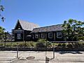
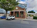
Ercildoune
Ercildoune is a beautiful historic home in Footscray, built in 1876. It's a significant example of the grand houses built in the area during that time.
ETA Foods Factory
The ETA Foods Factory in Braybrook was built in 1961. This factory is an important example of modern industrial design from the mid-20th century. It represents a time when new types of factories were being built.

Footscray Park
Footscray Park is a large and beautiful park in Footscray. It was first laid out in 1911 and has been a beloved green space for the community ever since. It's a wonderful place for recreation and enjoying nature.

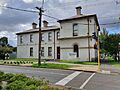
Footscray Primary School
Footscray Primary School, built in 1868, is one of the oldest schools in the area. Located in Footscray, it has educated generations of local children. Its long history makes it a special part of the community.
.jpg)
Footscray railway station
The Footscray railway station, built around 1900, is a key transport hub in Footscray. It has been serving train passengers for over a century, connecting people to different parts of Melbourne.

Footscray Town Hall
The Footscray Town Hall, built in 1936, is an impressive building in Footscray. It has served as the main civic building for the local government for many decades. It's a symbol of the community's history and growth.
.jpg)
Henderson House
Henderson House, built in 1872-73, is another historic home in Footscray. It offers a glimpse into the residential architecture of the late 19th century in the area.
Interlocking Railway Crossing Gates
These railway gates in Yarraville were installed around 1890. They are a rare example of early railway technology used to control train crossings. They show how railways were managed in the past.

Jack's Magazine
Jack's Magazine is a fascinating historic site in Maribyrnong, built between 1876 and 1878. It was once used to store explosives safely. It's a unique piece of industrial history.

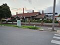
Kariwara District Scout Headquarters
This building in Footscray was built between 1925 and 1929 and has served as the Kariwara District Scout Headquarters. It's a place where many young people have learned important skills and values over the years.
.jpg)
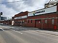
Kinnears Ropeworks
Kinnears Ropeworks, built in 1909 in Footscray, was a major factory that produced ropes. It's an important example of the industrial heritage of the Maribyrnong area.

Maribyrnong Migrant Hostel
The Maribyrnong Migrant Hostel in Maidstone was built in 1942. This hostel played a very important role in Australia's history, providing a first home for many migrants arriving in the country after World War II.
Maribyrnong Tram Substation
This tram substation in Maribyrnong was built between 1941 and 1942. It was essential for powering the tram network, helping people travel around the city. It shows the development of public transport.
Pipemakers Park Complex
The Pipemakers Park Complex in Maribyrnong dates back to 1868. This site has a long industrial history, including making pipes. Today, it's a park that tells the story of its past.
Royal Australian Field Artillery Barracks
These barracks in Maribyrnong were built in 1911. They served as a base for the Royal Australian Field Artillery, playing a role in Australia's military history.
Saltwater River Crossing Site and Footscray Wharves Precinct
This area on the west bank of the Maribyrnong River in Footscray has been important since the 1800s. It was a key crossing point and a busy wharf area, vital for trade and transport in early Melbourne.
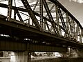
Saltwater River Rail Bridge
The Saltwater River Rail Bridge crosses the Maribyrnong River between Footscray and West Melbourne. Built between 1858 and 1859, it's one of Australia's oldest railway bridges. It's an amazing example of early engineering.

State Savings Bank Building
This building in Yarraville, constructed in 1909, was once a State Savings Bank. It represents the financial history of the area and the architectural style of banks from that period.
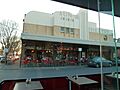
Sun Theatre
The Sun Theatre in Footscray was built in 1938. It's a beautiful art deco cinema that has entertained generations. It's still a popular place to watch movies today.

The Pebbles
"The Pebbles" is a unique building in Footscray, built in 1920. It's known for its distinctive design and is a notable example of architecture from that era.

Images for kids
-
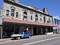
The historic Barkly Theatre in Footscray.
-
Ercildoune, a historic home in Footscray.
-
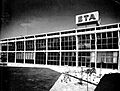
The ETA Foods Factory building.
-
The gates of Footscray Park at dusk.
-
Footscray Primary School building.
-
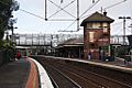
The signal box and footbridge at Footscray Station.
-
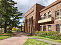
The grand Footscray Town Hall.
-
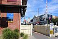
The historic level crossing gates in Yarraville.
-

Jack's Magazine, a historic explosives storage site.
-
Kariwara District Scout Headquarters.
-
Kinnears Ropeworks building.
-
The historic Saltwater River Rail Bridge.
-
The iconic Sun Theatre in Yarraville.
-
The unique building known as The Pebbles.
.jpg)
