
List of scheduled monuments in the Vale of Glamorgan facts for kids
The Vale of Glamorgan is a lovely rural area in south Wales. It's packed with history, boasting over 100 special places called scheduled monuments. These are important historical sites that are legally protected, like ancient buildings or old burial grounds.
These monuments tell us stories from different times. Forty-one of them are from prehistoric times, which means before written history. This includes three neolithic tombs (very old burial places), eighteen round barrows (mounds covering burials), and sixteen Iron Age hill forts (old fortified settlements on hills).
There are also four sites from the Roman period, including two Roman Villas. Seven sites are from the early medieval period (before the Normans arrived), mostly old chapels and crosses. The most visible remains are from the medieval period, with 52 monuments. These include seven castles and eighteen other defensive spots. You'll also find eight religious sites, like crosses, a chantry (a chapel for prayers), and a priory (a type of monastery).
Interestingly, four of the six sites from after the medieval period are from the 20th century. These are World War II defences, showing how history continues to be made. The entire Vale of Glamorgan is part of the historic county of Glamorgan.
These special sites are protected by Cadw, which is the Welsh government's historic environment service. They make sure these important places are looked after for everyone to enjoy. The information about these sites comes from Cadw, along with details from RCAHMW (the Royal Commission on the Ancient and Historical Monuments of Wales) and the Glamorgan-Gwent Archaeological Trust.
Contents
Discovering Ancient History: Prehistoric Sites
The Vale of Glamorgan is home to many amazing prehistoric sites. These places give us clues about how people lived thousands of years ago, long before cities and writing.
Neolithic Tombs: Ancient Burial Places
Some of the oldest monuments are neolithic tombs, which are huge stone structures used for burials.
- Tinkinswood Burial Chamber is a famous example. This large stone burial chamber was dug up in 1914. Inside, archaeologists found bones from at least 50 different people! It's now looked after by Cadw and you can visit it.
- St Lythans Burial Chamber is another impressive tomb. It was once covered by a mound of earth about 25 meters (80 feet) long. The giant capstone (the top stone) weighs an incredible 35 tons! This site is also cared for by Cadw and is open to the public.
Round Barrows: Burial Mounds
There are many round barrows in the Vale of Glamorgan. These are circular mounds of earth or stone that were built to cover burials, often from the Bronze Age. They show us how ancient people honored their dead.
Hill Forts: Iron Age Strongholds
The Iron Age saw the building of impressive hillforts. These were large settlements built on high ground, often surrounded by ditches and banks for protection.
- Dunraven Castle Hillfort is a great example. It sits on top of 60-meter (200-foot) sea-cliffs, overlooking the coast. Part of it has been lost to the sea over time. Inside, archaeologists have found traces of 21 roundhouses, showing where people lived.
- The Bulwarks Camp near Rhoose is another significant hillfort. These forts tell us about communities and how they defended themselves long ago.
Roman Life in Wales
The Romans were in Wales for hundreds of years, and they left their mark. In the Vale of Glamorgan, we can find remains of their presence.
- Knap Roman Site in Barry and Caermead Roman Site in Llantwit Major are both places where Roman villas once stood. Villas were large country houses, often like farms, where wealthy Romans lived. These sites give us a glimpse into Roman daily life in Wales.
Early Medieval Times: Chapels and Crosses
After the Romans left, a new period began, often called the Early Medieval period. This era saw the rise of early Christian sites.
- Llangan Celtic Cross is a beautiful example from the 9th or 10th century. It's a stone cross slab, about 1.3 meters (4 feet) tall, with carvings that show the crucifixion. It's protected within a shelter near St Canna's Church.
- St Barruch's Chapel in Barry is another early medieval site, showing the spread of Christianity.
Medieval Marvels: Castles and Villages
The medieval period (roughly 1066 to 1485) was a time of castles, churches, and bustling villages. The Vale of Glamorgan has many monuments from this exciting era.
Mighty Castles and Defences
Castles were very important for defence and power during the medieval period.
- Ogmore Castle is a spectacular ruin located between two rivers. It was built around 1116 or even earlier and has one of the oldest stone keeps (the main tower) in Wales. It's now looked after by Cadw and is a popular place to visit.
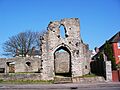
- St Quentin's Castle in Llanblethian is another important castle, also in the care of Cadw.
- Penmark Castle and Dinas Powis Castle are other examples of medieval castles in the area.
- You can also find motte castles, which are early types of castles built on a large earth mound, like Llanquian Castle and Felin Isaf Castle Mound.
Religious Sites and Crosses
Churches and religious buildings were central to medieval life.
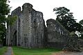
- Ewenny Priory is a well-preserved priory (a type of monastery) that is also looked after by Cadw.
- Many medieval crosses can be found in churchyards, like the St Mary Hill cross and the Medieval Cross in Churchyard at St Canna's Church in Llangan. These crosses often served as meeting points or places of prayer.
Medieval Villages and Homes
We can also find traces of where people lived and worked.
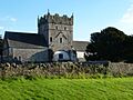
- Boverton Place and Llantwit Major Castle are examples of medieval manor houses. Boverton Place was built by Robert Fitzhamon and later rebuilt. Llantwit Major Castle is actually the ruin of an Elizabethan manor house built in 1596.
- Some sites are deserted medieval villages, like Llancadle Deserted Medieval Village. These are places where villages once thrived but were later abandoned, leaving behind only the foundations of their homes and streets.
- The Llantwit Major Dovecot is a unique building where doves were kept for food. It has a domed roof and is from the 13th century, showing how people managed their resources.
Later History: Post-Medieval and Modern Sites
History didn't stop in the medieval period! The Vale of Glamorgan also has monuments from more recent times.
- The Early Cement Works, Aberthaw shows us about industrial history.
- Some of the most recent scheduled monuments are from World War II. These include the Treguff RAF Airfield Decoy Control Centre, which was used to trick enemy planes, and the East Orchard Wood Pillbox, a small concrete bunker used for defence. The Limpert Bay Anti-invasion Defences and the Anti-aircraft and Coastal Battery W of Lavernock Point are also important reminders of this period.
These sites help us understand the Vale of Glamorgan's long and varied history, from ancient times to more recent conflicts.
Images for kids
-
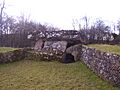
Stone burial chamber at Tinkinswood
-
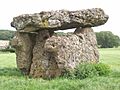
St Lythan's stone burial chamber
-
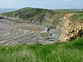
Trwyn y Witch headland, with the hillfort on its summit.
-
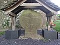
Llangan Celtic Cross
-
Barry Castle
-
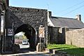
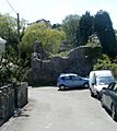
South Gate, Cowbridge
-
Saint Quentin's Castle
-
Ewenny Priory Church
-
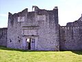
Beaupre Castle Gatehouse
-
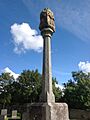
St Mary Hill cross
-
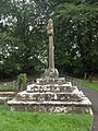
Medieval Cross in Churchyard, Llangan
-
Boverton Place
-
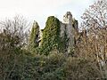
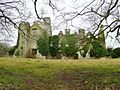
Ruins of Llantwit Major
-
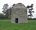
Domed dovecote at Llantwit Major Monastery
-
Gatehouse to the Grange, Llantwit Major
-
Llantwit Major Chantry
-
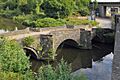
Leckwith Bridge
-
Penmark Castle, seen from the churchyard
-
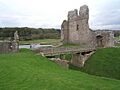
Ogmore Castle
-
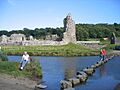
Stepping Stones on River Ogmore
-
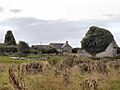
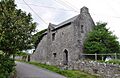
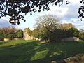
Farmhouse and ruins at Monknash


See also
