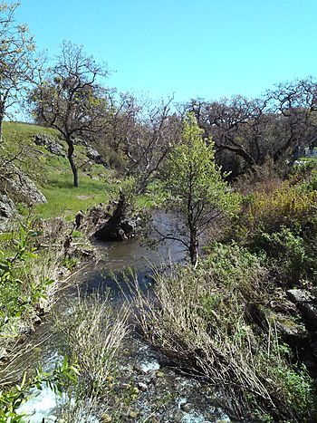
Little Uvas Creek facts for kids
Quick facts for kids Little Uvas Creek |
|
|---|---|

Little Uvas Creek along Uvas Road, March 2017
|
|
| Country | United States |
| State | California |
| Region | Santa Clara County |
| City | Morgan Hill, California |
| Physical characteristics | |
| Main source | On the northeastern flank of Loma Chiquita Ridge in the Santa Cruz Mountains 2,100 ft (640 m) 37°06′03″N 121°47′34″W / 37.10083°N 121.79278°W |
| River mouth | Confluence with Uvas Creek 530 ft (160 m) 37°06′04″N 121°43′19″W / 37.10111°N 121.72194°W |
| Length | 5.1 mi (8.2 km) |
Little Uvas Creek is a small, important stream located in the southwestern part of Santa Clara County, California. It's known as a perennial stream, which means it flows with water all year round, even during dry seasons. This creek is a natural landmark in the area, playing a role in the local environment.
About Little Uvas Creek
Little Uvas Creek is about 5.1 miles (8.2 kilometers) long. It's not a huge river, but it's a vital part of the water system in its region. The creek helps support local plants and animals. It also contributes to the larger water flow in the area.
Its Journey
The creek begins high up in the Santa Cruz Mountains. Its starting point, called the "headwaters," is on the northeastern side of a place called Loma Chiquita Ridge. From there, the water flows generally eastward.
As it travels, Little Uvas Creek eventually meets up with a larger waterway. It joins with Uvas Creek, which is another important stream in Santa Clara County. This meeting point is called a "confluence."
Following the Creek
If you look at a map, you'll notice a road named Little Uvas Road. This road runs right alongside the creek for most of its path. It's a scenic route that follows the natural twists and turns of the water. The road ends where it meets Uvas Road, near where the creek also joins Uvas Creek.
 | John T. Biggers |
 | Thomas Blackshear |
 | Mark Bradford |
 | Beverly Buchanan |

