
Loch Awe, Inchnadamph facts for kids
Quick facts for kids Loch Awe, Inchnadamph |
|
|---|---|

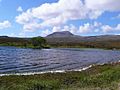
Loch Awe Trees have flourished on the islands, safe from grazing deer.
|
|

Loch Awe, Inchnadamph
Location in Sutherland
|
|
| Coordinates | 58°05′29″N 4°58′40″W / 58.09130096°N 4.97789574°W |
| Type | freshwater loch |
| Primary inflows | Unnamed burn that flows from Loch Na Gruagaich into the northern end of Loch Awe. |
| Primary outflows | River Loanan flows north from Loch Awe and drains into Loch Assynt |
| Max. length | 1.28 km (0.80 mi) |
| Max. width | 0.48 km (0.30 mi) |
| Surface area | 31 ha (77 acres) |
| Average depth | 4.92126 ft (1.50000 m) |
| Max. depth | 6.88976 ft (2.10000 m) |
| Water volume | 16,573,596.9 cu ft (469,312.00 m3) |
| Shore length1 | 4 km (2.5 mi) |
| Surface elevation | 154 m (505 ft) |
| Max. temperature | 53.5 °F (11.9 °C) |
| Min. temperature | 3.5 °F (−15.8 °C) |
| 1 Shore length is not a well-defined measure. | |
Loch Awe is a beautiful freshwater loch (which is the Scottish word for lake) located in the stunning Assynt area of Sutherland, Scotland. It's about 4 miles south of Loch Assynt and the small village of Ledmore. This area, along with nearby Coigach, is so special that it's called the Assynt-Coigach National Scenic Area. This means it's one of 40 places in Scotland recognized for its amazing natural beauty.
Contents
Discovering the Ancient Cairn at Loch Awe
Just south and west of Loch Awe, you can find an ancient stone structure called a cairn. This cairn is located at a spot known as Cnoc Bad Na Cleithe.
What is a Cairn?
A cairn is a pile of stones built by people, often in ancient times. They were used for many reasons, like marking a burial site, a special place, or a path. This particular cairn is circular in shape.
Exploring the Cairn's Size and History
The cairn at Cnoc Bad Na Cleithe stands about 6 to 7 feet tall. At its base, it measures roughly 63 feet from north to south and 70 feet across. Experts surveyed this ancient monument on June 11, 1909. They found no signs of a cist (a stone box for burials) or a chamber inside it. This suggests it might have been a marker or a ceremonial site rather than a burial place.
Images for kids
-
Loch Awe and Canisp in the distance

