Loch Derculich facts for kids
Quick facts for kids Loch Derculich |
|
|---|---|

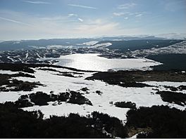
Frozen Loch Derculich
|
|
| Coordinates | 56°40′22″N 3°51′16″W / 56.6727°N 3.8545°W |
| Type | freshwater loch |
| River sources | Derculich Burn |
| Max. length | 0.804 km (0.500 mi) |
| Max. width | 0.402 km (0.250 mi) |
| Surface area | 39.9 ha (99 acres) |
| Average depth | 25 ft (7.6 m) |
| Max. depth | 70 ft (21 m) |
| Water volume | 108,333,000 cu ft (3,067,600 m3) |
| Shore length1 | 3.3 km (2.1 mi) |
| Surface elevation | 367 m (1,204 ft) |
| Max. temperature | 55 °F (13 °C) |
| Min. temperature | 47 °F (8 °C) |
| Settlements | Aberfeldy |
| 1 Shore length is not a well-defined measure. | |
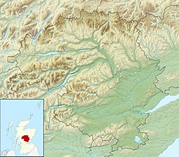
Loch Derculich is a beautiful freshwater loch (that's the Scottish word for lake!) located in the central Highlands of Scotland. You can find it in an area called Perth and Kinross. This peaceful loch is about three miles south of another well-known loch, Loch Tummel.
Contents
Exploring Loch Derculich
Loch Derculich is a natural body of water fed by the Derculich Burn. It's a freshwater loch, which means its water is not salty like the ocean. The loch is quite long, stretching about 0.8 kilometers (0.5 miles). It is also about 0.4 kilometers (0.25 miles) wide.
The deepest part of Loch Derculich is about 21 meters (70 feet) deep. This makes it a fairly deep loch for its size. The loch is located at an elevation of 367 meters (1,204 feet) above sea level. This high elevation means it's nestled among the hills and mountains of the Highlands.
Life Around the Loch
The area around Loch Derculich is quiet and natural. The nearest town is Aberfeldy, which is a short distance away. The loch's shore stretches for about 3.3 kilometers (2.1 miles). This provides a habitat for various plants and animals.
The water temperature in the loch can vary. It usually ranges from about 8 to 13 degrees Celsius (47 to 55 degrees Fahrenheit). In winter, the loch can sometimes freeze over, as shown in the picture.
Ancient Homes by the Loch
Long ago, people lived and worked around Loch Derculich. We know this because of special aerial photography. This type of photography takes pictures from above, showing details on the ground that might be hard to see otherwise.
On the south side of Loch Derculich, there are signs of old buildings. These are called shieling huts. A shieling hut was a simple shelter used by shepherds and their families. They would live there during the summer months while their animals grazed in the high pastures.
What Were Shieling Huts?
Shieling huts were usually small, temporary homes. They were often made from local materials like stone and turf. People would move to these huts with their livestock, such as sheep or cattle. This allowed the animals to feed on fresh grass in the hills.
The aerial photos show two groups of these huts near a gully. There's also an old trackway that runs southwest from where the huts were. This track was likely used by people and animals to travel.
Discovering Hut-Circles
Near the shieling huts, there might also be a hut-circle. A hut-circle is the remains of a very old, round house. These homes were used by people even longer ago than the shieling huts. They show that people have lived in this area for many centuries.
These ancient remains tell us about the history of human life in the Scottish Highlands. They show how people adapted to the landscape and used its resources.


