Loch Tummel facts for kids
Quick facts for kids Loch Tummel |
|
|---|---|

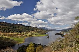
The 'Queen's View'
|
|
| Location | Perth and Kinross, Scotland |
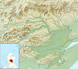
| Coordinates | 56°42′39″N 3°55′44″W / 56.7107°N 3.9290°W |
| Type | freshwater loch |
| Basin countries | Scotland |
| Max. length | 11 km (7 mi) |
| Max. width | < 1.6 km (1 mi) |
| Surface area | 579.1 ha (1,431 acres) |
| Max. depth | 44 m (145 ft) |
| Shore length1 | 27.2 km (16.9 mi) |
| Surface elevation | 142 m (466 ft) |
| 1 Shore length is not a well-defined measure. | |
Loch Tummel (in Scottish Gaelic: Loch Teimheil) is a long, narrow loch (which is the Scottish word for lake). It's located about 7 kilometers (4.3 miles) northwest of Pitlochry in Perth and Kinross, Scotland. The River Tummel flows into and out of the loch. This river then joins the River Tay further southeast.
Roads run along both sides of Loch Tummel. The northern road is called the B8019. It goes from the Pass of Killiecrankie to Tummel Bridge. The southern road is smaller and connects to the A9 road near Pitlochry.
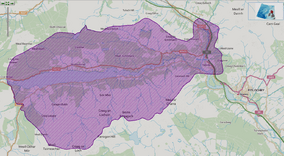
Loch Tummel is part of the Loch Tummel National Scenic Area (NSA). Scotland has 40 such areas. They are special places with amazing scenery. These areas are protected to keep them beautiful. The Loch Tummel NSA covers about 90 square kilometers (35 square miles). It includes the hills around the loch and the area near the Pass of Killiecrankie.
Contents
Fun Things to Do at Loch Tummel
Loch Tummel is a great place for outdoor activities! Many people enjoy fishing here. You can catch brown trout and pike. The Loch Rannoch Conservation Association manages fishing and issues permits.
If you like sailing, the Loch Tummel Sailing Club is located at Foss. It's on the southwest side of the loch. Camping is also very popular here, especially in spring and summer.
The roads around the loch offer fantastic views. One of the most famous spots is the 'Queen's View'.
The Famous Queen's View
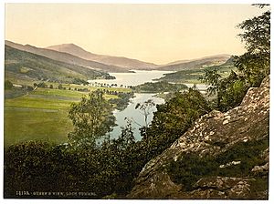
The 'Queen's View' is on the north shore of Loch Tummel. It became famous after Queen Victoria visited in 1866. She loved the magnificent view over the loch with Schiehallion mountain in the background.
Some people say the view was actually named after Queen Isabel. She was the wife of Robert the Bruce. Legend says she hid in the nearby woods in 1306. This was after her husband's defeat at the Battle of Methven.
The forests around Loch Tummel are managed by Forestry and Land Scotland (FLS). They are part of the Tay Forest Park. This park has many forests in the Highland parts of Perthshire. They offer great walks and facilities for visitors.
Animals and Nature Around the Loch
The River Tummel flows into the River Tay. Loch Tummel is part of the River Tay Special Area of Conservation. This means the river system is very important for certain animals. These include salmon, otters, and different kinds of lampreys (brook, river, and sea lampreys). You can also find Brown trout and pike in the loch.
The woods north of the loch are home to many protected species. These include large birds like capercaillie and black grouse. You might also spot red squirrels. Rare butterflies like the pearl-bordered fritillary live here too. The area also has juniper plants.
How Loch Tummel Helps Make Electricity
Loch Tummel is an important part of the Tummel Hydro-Electric Power Scheme. This scheme uses water to create electricity. In 1950, the Clunie Dam was built at the eastern end of the loch. This dam raised the water level by about 4.5 meters (15 feet). Before the dam, the loch was smaller. It was about 4.4 kilometers (2.7 miles) long and 0.8 kilometers (0.5 miles) wide. Now, it's about 7 kilometers (4.3 miles) long and almost 1.6 kilometers (1 mile) wide.
Water from Loch Tummel flows to Loch Faskally. It passes through the Clunie power station. This station uses the falling water to generate a lot of electricity. There's another power station at Tummel Bridge, at the western end of the loch. This station takes water from Dunalastair reservoir and releases it into Loch Tummel. Both stations help provide power for homes and businesses.
Step Back in Time: History of Loch Tummel
The northern side of Loch Tummel has many old historical sites. You can find an Iron Age ring fort. There are also remains of old villages and Pictish fortified settlements. The standing stones of Clachan Aoraidh are located in the Allean Forest. Fincastle House, a historic building from the 1600s, is also nearby.
Ancient Discoveries Underwater
When the loch's water level was raised for electricity, an artificial island called a crannog was covered. This island is now about 3 meters (10 feet) underwater. In 2004, experts explored it. They found a well-made stone floor and steps that led down to the old loch bed. A piece of wood found there was from around 1840.
Old Bridges and Roads
At the head of the loch, there are two bridges over the River Tummel at Tummel Bridge. One is an old humpbacked bridge built by General Wade around 1734. He built many roads and bridges in Scotland to help the army move around. A newer bridge next to Wade's bridge carries today's traffic.
The historic drove road known as the Road to the Isles also starts near Wade's military road at Tummel Bridge. This old road was used to move cattle. Tummel is even mentioned in a famous Scottish folk song named after the road!
 | Leon Lynch |
 | Milton P. Webster |
 | Ferdinand Smith |


