
Schiehallion facts for kids
Quick facts for kids Schiehallion |
|
|---|---|
| Sìdh Chailleann | |

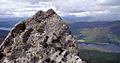
The north-west ridge of Schiehallion in April
|
|
| Highest point | |
| Elevation | 1,083 m (3,553 ft) |
| Prominence | c. 716 m |
| Parent peak | Ben Lawers |
| Listing | Munro, Marilyn |
| Naming | |
| English translation | Fairy Hill of the Caledonians |
| Language of name | Gaelic |
| Geography | |

Schiehallion
Location in Perth and Kinross
|
|
| OS grid | NN714548 |
| Topo map | OS Landranger 51 |
Schiehallion (Scottish Gaelic: Sìdh Chailleann) is a famous mountain in Perth and Kinross, Scotland. This mountain is special because of its plant life, old historical sites, and a very important science experiment from the 1700s. In this experiment, scientists tried to "weigh the Earth" using the mountain!
Because many people love to hike Schiehallion, its walking paths became worn out. Big repairs were done in 2001 to fix them. The name Schiehallion comes from the Gaelic words Sìdh Chailleann. This means "Mound of the Caledonians".
Contents
Where is Schiehallion Located?
Schiehallion sits between three lochs: Loch Tay, Loch Rannoch, and Loch Tummel. It is about 10 miles (16 km) west-north-west of Aberfeldy in Perthshire.
The mountain is 1,083 metres (3,553 ft) high. It stands alone from other peaks. From the west, it looks almost like a perfect cone. Many visitors enjoy the view of its wide eastern side from the shores of Loch Tummel. Some people even call Schiehallion the "centre of Scotland"!
Plants and Nature on Schiehallion
The slopes of Schiehallion are full of different kinds of plants. You can find heather, mosses, and blaeberry here. The colours of the blanket bog and heather moorland change with the seasons.
There are also areas of limestone pavement. This special type of rock provides nutrients for plants. Because of this, you can see plants like dog's mercury, lily of the valley, and wood anemone growing there.
How Schiehallion was Formed
Most of Schiehallion is made of a rock called quartzite. This rock forms when sand is heated and squeezed under great pressure. Quartzite is usually white or pink. Its main mineral is quartz.
Many people think Schiehallion is an old volcano because of its cone shape. But it's not! It was formed by sand settling over time. Its shape comes from ice wearing it down during the ice ages.
History of Schiehallion
People have lived and farmed on the slopes of Schiehallion for a very long time. They were there from about 1,000 BC until about 200 years ago. The mountain has also been used for grazing sheep and hunting red deer.
Since 1999, the eastern side of the mountain has been owned by the John Muir Trust. This group works to protect wild places.
The Schiehallion Experiment: Weighing the Earth

Schiehallion was chosen for a very important science experiment in 1774. Because it stands alone and has a regular shape, it was perfect for trying to figure out the mass of the Earth.
Here's how it worked: Scientists measured how much a pendulum was pulled sideways by the mountain's gravity. From this, they could guess the average density of the Earth. Once they knew the density, they could calculate the Earth's total mass and a value for Newton's gravitational constant G.
Charles Mason was first asked to do this work, but he turned it down. So, the Astronomer Royal, Nevil Maskelyne, led the project. A mathematician named Charles Hutton helped him. Hutton even created a new way to draw maps using lines to show different heights. These are now called contour lines!
Hiking Schiehallion
Schiehallion is a Munro mountain, which means it's over 3,000 feet (914 metres) high. It's very popular with hikers because it's easy to get to, not too hard to climb, and has amazing views from the top. In the year 2000, about 17,500 to 20,000 people climbed it!
Most hikers start from the Forestry and Land Scotland car park at Brae of Foss. This spot is just outside the land owned by the John Muir Trust. The path is about 4.5 kilometres (2.8 mi) long. It first goes southwest, then turns west to follow the main ridge of the hill.
From the top of Schiehallion, you can see Ben Nevis to the west. Ben Nevis is the highest mountain in the British Isles!
By 1999, when the John Muir Trust bought the land, the main path was very eroded from so many walkers. The damage could be seen from far away. So, the Trust decided to build a new path. This new path follows a different route and is better designed to handle all the visitors.
Schiehallion in Culture
The Schiehallion oilfield is an oil field named after the mountain. It's one of the biggest oil fields on Scotland’s continental shelf. It's operated by BP and is about 180 miles (290 km) west of Shetland in the North Atlantic.
Schiehallion has also appeared in other parts of culture:
- It was the setting for the final battle in Grant Morrison's comic series Zenith.
- The Harviestoun Brewery makes a cask-conditioned lager called Schiehallion.
- There's a Scottish country dance called "Schiehallion" and a dance move called the Schiehallion Reel.
- A song named "Schiehallion" was on the 1994 album Time For A New Day by the independent band King Rizla.
- Pipe Major Donald Shaw Ramsay wrote a march called "Schiehallion".
- An England-based band called "Schiehallion Pipes and Drums" uses this march as their main song.
- The power metal band Gloryhammer sings about a made-up version of Schiehallion in their song “The Fires of Ancient Cosmic Destiny.” In the song, it has "raging volcanic fires," which is a fun nod to the common mistake that the real mountain is a volcano.
Gallery
-

View from the summit of Schiehallion looking over Loch Rannoch into the setting sun
-
View from summit of Schiehallion towards Loch Tummel
Jun1998.jpg)

