
Loch Fergus facts for kids
Quick facts for kids Loch Fergus |
|
|---|---|

Loch Fergus
|
|
| Lua error in Module:Location_map at line 420: attempt to index field 'wikibase' (a nil value). | |
| Location | Coylton, South Ayrshire, Scotland |
| Type | Freshwater loch |
| Primary inflows | Knocksoul Burn, rainwater and field drainage |
| Primary outflows | Loch Fergus Burn |
| Basin countries | Scotland |
| Max. length | c. 680 yd (620 m) |
| Surface area | 7.044 ha (17.41 acres) |
| Islands | One Island |
| Settlements | Ayr |
Loch Fergus (pronounced 'Lock') is a freshwater loch, which is a Scottish word for a lake. It's also sometimes called Fergus Loch. This loch was formed after the last Ice Age in a special type of hollow called a "kettle hole."
It's easy to spot and sits in a low-lying area in South Ayrshire, Scotland. You can find it close to the B742 road, between farms and homes like Trees, Lochfergus, and Bowmanston. Loch Fergus is located north of Martnaham Loch, about 4 miles (6.4 km) east-southeast of Ayr. Its water flows southwest into the Snipe Loch.
Contents
History of Loch Fergus
The ground around Loch Fergus, especially towards Mossend Farm, is quite marshy. This area often floods, which shows that the loch used to be much larger than it is today. The water now flows out through a drain. However, you can still see physical signs of where the loch's edges were when the water levels were higher.
In an old book from 1624, A Summary of the Character of Scotland, it was written that Loch Fergus had an island with many trees. It also mentioned that many herons lived there and that there was a ruined monastery on the island. Loch Fergus is even mentioned in a very old document from King William in 1205. This document helped to define the boundaries of the town of Ayr.
The Legend of King Fergus

Local stories say that Loch Fergus gets its name from King Fergus. He was one of the Scottish kings who fought and defeated King Cole or Coilus, who was a king of the Britons. This battle supposedly happened in the fields right next to the loch.
The story tells that King Cole and his army were camping near Loch Fergus. King Fergus attacked them at night when they were not expecting it. King Cole and his defeated army tried to escape by crossing the Water of Coyle. But they were caught, defeated again, and King Cole himself was killed near Failford. Some records suggest that King Cole might have had a castle on an island in Martnaham Loch, another nearby loch.
The land around Loch Fergus is quite wet and marshy. Lochfergus Wood, a wooded area, has been a notable feature for many years, mostly on the northwest side of the loch. Old maps show that there was once a boat house near the road, reached by a small lane. This boat house was no longer on maps by the 1890s.
The Island in the Loch
The island in Loch Fergus is roughly oval-shaped. It's about 190 yards (174 meters) long and covers about 0.814 hectares (2 acres). People say that a causeway, which is like a raised path, used to connect the island to the bank near Lochfergus Farm. However, this causeway is no longer there.
On the island, there are two low piles of boulders that don't have a clear shape. These might be the remains of an old building. A detailed map from the Ordnance Survey (OS) shows a small rectangular structure near the center of the island. In 1976, a fishing club-house was built about ten meters from these ruins. The island is now covered in thick plants and trees. The Scottish Wildlife Trust has named the island a Local Nature Conservation Site (LNCS). Maps show that it has been covered in woodland for a long time.
The Friary Legend
In the "Chronicles of Scotland" from 1624, it's written that a friary (a type of religious building) existed on the island. Local place names like Abbothill and Friarland seem to support this idea. However, some people think that the scattered stones on the island might have led to this legend. They suggest the island was actually used as a crannog. A crannog is an ancient artificial island, often built for defense or living. Other ideas are that the ruins might be related to wildfowling, perhaps being the remains of a duck decoy.
The Old Hunting Lodge
Nothing remains today of an old hunting lodge that belonged to the Kennedy family. This lodge was described in 1837 as "an old ruined castle." It was probably used by the Cassillis family for shooting. It was said to have stood near the edge of Loch Fergus, close to a track leading off the B742 road. This building is thought to have been a Tower House, but it's not clear when it was built.
Transport Routes of the Past
An old trackway, known as the "Foul Calsey" or causeway, used to run from Loch Fergus. It passed by Trees, Macnairston, and Crofthead before reaching Ayr. It then joined the Cumnock Road near Holmston. This old road was still used by farmers until the 1920s, especially during harvest time. Later, farmers cleared away tracks like this. They did this because the tracks took up valuable land that could be used for crops and could also damage their ploughs.
Interesting Facts About Loch Fergus
The fields around Loch Fergus are a great place to see Whooper Swans.
There's a roughly circular earthwork, which is a man-made mound of earth, called Highpark or Laighpark. Its purpose and age are unknown. It's located on the slopes northeast of the loch. This earthwork is about 45 meters (148 feet) across and sits within a ditch. A break in the ditch on the east side might show where the original entrance was.
Loch Fergus is a popular spot for coarse fishing. You can catch fish like roach, pike, and perch here. People say that the loch is unusually deep for a typical kettle hole.
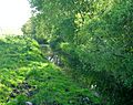
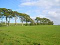
Images for kids
-
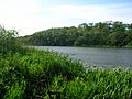
The southern end of Loch Fergus
-
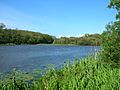
The loch and the island
-
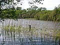
The northern end of the loch
-
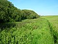
The willow woodlands on the lochshore
-
The Loch Fergus Burn outflow
-
The old lane running down to the boathouse


See also
