Longares facts for kids
Quick facts for kids
Longares
|
||
|---|---|---|
 |
||
|
||
| Country | ||
| Autonomous community | ||
| Province | Zaragoza | |
| Area | ||
| • Total | 45.7 km2 (17.6 sq mi) | |
| Elevation | 531 m (1,742 ft) | |
| Population
(2018)
|
||
| • Total | 763 | |
| • Density | 16.696/km2 (43.24/sq mi) | |
| Time zone | UTC+1 (CET) | |
| • Summer (DST) | UTC+2 (CEST) | |
| Postal Code |
50460
|
|
| Area Code | (+34) 976 | |
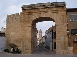
Longares is a small town, also called a municipality, located in the province of Zaragoza. This area is part of Aragon, one of Spain's autonomous communities. In 2018, about 763 people lived in Longares.
The town is known for the Cabezo de Altomira hill. This hill stands out in the mostly flat land around Longares. You can see it to the northwest of the town.
About Longares
Longares is a quiet place in the Spanish countryside. It is part of the larger region of Aragon. The town is located in the province of Zaragoza. This province is in northeastern Spain.
What is a Municipality?
A municipality is like a local government area. It includes a town or city and the land around it. Longares is one such area. It has its own local leaders.
Who Leads Longares?
The main leader of Longares is called the Mayor. The mayor helps run the town. They make decisions for the community. The current mayor of Longares is Miguel Jaime Angos. He belongs to a political party called CHA.
How Big is Longares?
The total area of Longares is about 45.7 square kilometers. This is roughly 17.6 square miles. The town is located at an elevation of 531 meters (1,742 feet) above sea level.
See also
 In Spanish: Longares para niños
 | John T. Biggers |
 | Thomas Blackshear |
 | Mark Bradford |
 | Beverly Buchanan |


